>
In Today’s Blog
UK Weather Discussion @ #BRITISH ISLES-EUROPE
Update: Current GFS model shows a 956mb central pressure core just off Scotland By Monday!
Tropical Update @ #WEATHER TALK
Latest Information From the Tropics
GLASGOW-EDINBURGH CORRIDOR MAY SEE WIND GUSTS OF 70-80MPH
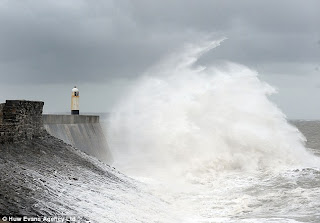
The Potential is there that we could see a Scotland-wide DAMAGING WIND EVENT starting SUNDAY NIGHT THROUGH MONDAY AND POSSIBLY TUESDAY
Related Stories
Britain braced for severe gales on Sunday
BBC
US hurricane centre in storm warning for Scotland
BBC
See #BRITISH ISLES-EUROPE FOR INITIAL THOUGHTS AND FORECASTS.. THIS WILL BE UPDATED THROUGHOUT. STAY TUNED.
Mid-Atlantic Suffer Worst Flooding Since Agnes of 1972
FROM ACCUWEATHER.COM
These are the official National Weather Service Hydrological projected levels and current records for key points along the Susquehanna River:
Binghamton, N.Y.: 25.7 feet / 25.0 feet June 2006 Record crest has occurred.
Wilkes-Barre, Pa: 38.8 feet / falling short of 40.9 feet June 1972 crest.
Danville, Pa.: 31.8 feet / 32.3 feet June 1972 Crest expected Friday P.M.
Sunbury, Pa.: 31.7 feet / 35.8 feet June 1972 Crest has occurred.
Harrisburg, Pa.: 26.5 feet / 32.6 feet June 1972 Crest may have occurred at 25.2 feet.
Conowingo Dam, Md.: 32.9 feet / 36.8 feet June 1972 Gates are open.
In Luzerne County, Pa. alone, around 70,000 people were evacuated on Thursday.
Record Flooding: Bridges, Levees, Dams Being Tested
ACCUWEATHER.COM
Obama signs disaster declarations for Northeast flooding
CNN
Northeast floodwaters recede, toxins, sewage left behind
NBC NEWS
Floodwaters plaguing Northeast start to recede
CBS NEWS
Northeast Flooding: Five Dead as 100K Evacuate
ABC NEWS
Worst Wildfire in Texas History: Nearly 1, 400 homes Burned Down!
Officials: Fire Retardant-Dumping Jet Heads to Houston
FOX NEWS
THE EXTREMES OF THE DAY
TODAY’S US EXTREMES
COURTESY OF ACCUWEATHER
HIGH: 111° at Gila Bend, AZ
LOW: 28° at West Yellowstone, MT
TODAY’S UK EXTREMES
COURTESY OF THE MET OFFICE
HIGH: 77° (24.8°C) at Wainfleet (Lincolnshire)
LOW: 43° (5.9°C) at Braemar (Aberdeenshire)
TODAY’S EXTREMES HERE AT MY HOUSE
HIGH: 63°
LOW: 48°
Thanks for reading.
-Mark


Recent Comments