>
In Today’s Blog
#BRITISH-ISLES-EUROPE
Little change to the unsettled UK pattern in the next 7-10 days, always drier and warmer towards London (includes 4-day European city forecast & video)
#USA
Sunday Soaker for East Coast, 3+ inches of rain expected between New York City & DC, Severe Storms possible, Houston to top 100 for 14th straight day
In Today’s News
BREAKING NEWS
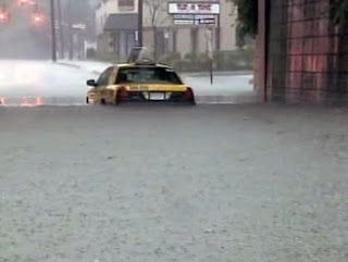
PARTS OF NYC & LONG ISLAND IS UNDER WATER DUE TO EXCESSIVE RAINS, HOUSTON TIES 1980 FOR MOST CONSECUTIVE DAYS ON RECORD THIS AFTERNOON
RAIN TOTALS AS OF 4PM ET
Elmer, NJ 9.36″
JFK, NYC 7.72″ (highest 24-hour total on record)
Philadelphia, PA 4.90″ (4th highest total on record)
NEW: Heavy Rains Flood Streets, Trap Cars In Parts Of NYC And Long Island
CBS NEW YORK
NEW: Houston hits 100 degrees, tying record, before the rain comes
HOUSTON CHRONICLE
Strong Thunderstorms Illustrate Their Danger In Devastating Fashion at Indiana State Fair Saturday Night
5 Dead as Indiana State Fair Stage Collapses
THE WEATHER CHANNEL
It was a devastating sight just watching the video of the concert stage collapsing in Indianapolis last night. This was a result of winds blowing out from a thunderstorm cluster moving towards the State Fair site from the NW. An outflow boundary is when a powerful downward column of air, released from the storm hits the ground and then moves out and away from the storm, these winds are powerful and what we saw in the video from last night was a direct result of just how dangerous outflow boundaries can be if your in the wrong place at the wrong time.
Two Sides to Outflow Boundaries
Ironically, for Dallas just a few days ago, an outflow boundary was Dallas’ best friend, erasing the heat from 96 to 84 in less than an hour. It also stopped the city from challenging the 1980 heat record for most consecutive 100-degree days. As for last night, the exact same phenomenon created devastation, and showed in such a raw way the other side of the coin when it comes to outflow boundaries.
2nd concert stage collapse in less than a month in North America due to severe thunderstorms
The video below was from the Bluesfest Concert in Ottawa, Ontario, Canada just last month.
Sunday Soaker for US East, 5+ inches expected in New Jersey
Sunday Weather: Bouts Of Rain, Heavy At Times
CBS NEW YORK
Soggy, Soaking, Stormy Type Of Day
PHILLY WEATHER
New Zealand Hit by Big Antarctic Storm
Snowfall traps motorists
NZHERALD.CO.NZ
Rare weather forecast for Auckland
NZHERALD.CO.NZ
THE EXTREMES OF THE DAY
TODAY’S US EXTREMES
COURTESY OF ACCUWEATHER
HIGH: 112° at Bullhead City, AZ
LOW: 35° at Stanley, ID
TODAY’S UK EXTREMES
COURTESY OF THE MET OFFICE
HIGH: 74° (23.4°C) at Writtle (Essex)
LOW: 41° (5C) at Kinbrace (Highland)
TODAY’S EXTREMES HERE AT MY HOUSE
HIGH: 64°
LOW: 50°
Thanks for reading.
-Mark


Recent Comments