>
On Weather & Climate Through the Eyes of Mark Vogan
Heavy Rains Pound India
ACCUWEATHER.COM
Rain, Flooding in China Prompts Evacuations
ACCUWEATHER.COM
Scientists see sunspot “hibernation” but no Ice Age
Yahoo News
TODAY’S WEATHER ACROSS UK & EUROPE By Mark Vogan
Continent split between cool, unsettled across UK/Scandinavia, Warm to hot from Spain across Med!
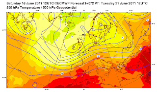
The upper pattern is such right now that we’re seeing a basic north-south divide in the continent’s weather with the UK the epicenter of cool, unsettled weather which spreads due east across Norway, Sweden and Denmark as well as southeast into France and Germany. Here we see temps either at or slightly below normal with only 18-20C across southeast England, into northern France, 21-23C across Germany and Poland where showers are frequent and at times heavy and persistent.
By Thursday, it appears the trough rebuilds south from the UK and back into France, Germany and into Poland bringing a return once again a return to subpar highs only in the 17 to 21C range along with cloud and showers. The southern portions of Europe from Spain across the Mediterranean Sea will remain hot, dry and sunny.
TODAY’S WEATHER ACROSS AMERICA By Mark Vogan
Severe Thunderstorms race across Midsection into Ohio Valley
Fierce Heat is Currently Roasting Texas and South
KHou.com Evening Forecast
WEATHER TALK
By Mark Vogan
Midnight Sun and White Nights approach their peak as Summer Solstice nears!
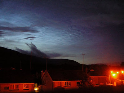
At 52 degrees north in latitude, I reside on the southernmost periphery of the ‘White Night’ zone in the Northern Hemisphere where sunset is late, sunrise is early and complete darkness on the northern horizon on clear nights doesn’t occur, yes, ever noticed on clear nights in June where there is daylight to the north even at midnight, 1 and 2pm, beyond 2am, the skies are growing brighter once again.
Once you pass 60 degrees north, the sky will be brighter all night and up towards the Arctic Circle, a midnight sky may resemble 3pm. Beyond the Arctic Circle and the sun never falls below the horizon.
The top photo was taken by myself at 12.30am Friday morning and this shot doesn’t give justice to just how bright our midnight sky can really be even this far south. The picture immidiately above shows better the brightness of the skjy at 1.45am and by the point in which this picture was taken, the sky was growing brighter with the light travelling west to east along the northern horizon.
WHAT’S REACHING TODAY’S BLOGS?
Busy With Heat, Storms, and Tropics
Frank Strait, AccuWeather
Summer Solstice
Astronomy Blog, AccuWeather
THE EXTREMES OF THE DAY
TODAY’S US EXTREMES
COURTESY OF ACCUWEATHER
HIGH: 112° at Laredo, TX
LOW: 28° at Stanley, ID
TODAY’S UK EXTREMES
COURTESY OF THE MET OFFICE
HIGH: 66° (19.1C) at Murlough (Co Down)
LOW: 38° (3.3C) at Katesbridge (Co Down)
TODAY’S EXTREMES HERE AT MY HOUSE
HIGH: 59°
LOW: 47°
Thanks for reading.
-Mark


Recent Comments