>
On Weather & Climate Through the Eyes of Mark Vogan

Officials: 232 unaccounted for in Joplin twister
ABC NEWS
Super Typhoon Songda Could Pass Near Okinawa
ACCUWEATHER.COM
Super Typhoon Songda set to lash China, Japan (PHOTOS)
WJLA.COM
Warm Afternoon across Mid-Atlantic USA
Just wait till next week!!!

TODAY’S WEATHER ACROSS AMERICA By Mark Vogan
Today to mark final day in latest Severe Weather Cycle, Major Warming looms for early Next Week!
THREAT ZONE TODAY SPANS A HUGE AREA OF REAL ESTATE
CENTRAL ALABAMA ALL THE WAY TO SOUTHERN ONTARIO MAY SEE SEVERE THUNDERSTORMS AND POSSIBLY TORNADOES FORM
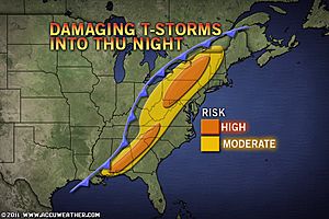
Despite the atmospheric mechanics breaking down as the low and boundary creeps further east from the central Plains yesterday to the eastern Great Lakes and Appalachains today, the threat remains dangerous for anywhere that eyes thunderstorms that become strong and start rotating.
The problem today becomes, the danger of a supercell, though lesser in likihood as well as number, those that do form may eye a major metropolitan area. A large swath of the country stretching from central Alabama all the way to Southern Ontario is at risk this afternoon and evening. Though this region lies within the crossroads of converging air and strong upper-level energy and wind sheer, one key elemane twhich has driven the massive supercells and tornadoes of recent days, HUMIDITY, isn’t quite as high-octane and as available. However, there is plentiful moisture and a lot of surface heat for this boundary to work with so still please be on guard!
The cities at risk from severe waether today include
Birmingham
Pittsburgh
Toronto
As for Friday’s risk, well the threat continues shifting east. Hail and Damaging winds more of a concern rather than tornadoes.

Once the Severe Weather loose the highlines come this weekend, all eyes watch Super Typhoon Sangda bend around the western Pacific pumping a HIGH across the US

It’s often said that a western Pacific Typhoon which rides around the western flank of the North Pacific High will feed a deepening eastern Pacific trough. In turn an intensifying high pressure system will build across the USA and the models are showing a major warming event early next week from the Rockies to Eastern Seaboard.
In fact, intense heat is building over interior Mexico at the moment which is leading to hot conditions across the Rio Grande Valley of Texas. However, as the trough deepens off the west coast of the US by the weekend, watch as this heat core expands northwards into the central plains at the same time pressures build north and eastwards across the country.
TODAY’S WEATHER ACROSS UK & EUROPE By Mark Vogan
Majority of UK remains locked in cool, wet pattern, Spain to commence cooldown while rest of mainland begins to heat back up with corridor from Paris to Moscow eyeing 25 to 30C
The big picture over the next 24 hours


On the large picture, the European continent is split beneath two very different, conflicting air masses. A cold air mass aloft (centered over Britain and Ireland) and and a warm air mass aloft (centered over eastern Spain). In between we see a boundary which is producing a channel of heavy rains across an area stretching from the Pyrenees, French Alps, up through Austria and Switzerland up through the Baltic States and west Russia. At the moment, we have 3 main players within the this pattern 1) A large low that’s prgressing from Scotland into Southern Norway which is pulling the front deep into Frabce, bringing cloud, rain and much cooler temps 2) An upper low to the SW of Portugal is feeding moisture into a hot air mass, creating widespread shower activity through Iberia and 3) An upper low over Greece which is also enhancing the shower and thunderstorm activity over southeast Europe from Greece into Turkey and across the eastern Med Basin where frequent thundery showers are affecting Cyprus.
The picture Saturday through Sunday
Over the course of Friday and Saturday it appears the upper low off SW Iberia will progress towards Portugal, further increasing cloudiness and rains. This will drop temps from the 28-35C range down into the 22-25C range across the Peninsula. At the same time, the trough begins orienting in a west-east fashion which will allowed the boundary drapped across south-central France, through the Alps and up into the Baltic States to rebound northwestwards. As this boundary shifts northwest, the ridge will begin to intensify on Sunday from southern France north and east pushing warm air across the mainland, through Germany, Poland and up towards Moscow. The Iberian Peninsula will see highs across much of the region continue falling, while to the north over France they will continue rising as skies grow sunnier and much warmer again.


As an example, Scotland will remain locked beneath the cold pool aloft as more low pressure impulses ride a strong Atlantic jet. However, by the straightening up of the jet and northwest rebound of the boundary which seperates the cold with warm, the French upper level high will get cranking allowing Paris to warm by Sunday back towards 25 or 26C and by Monday 29 or 30C. The jet only reaches so far north, only perhaps as far north as Cumbria, at best.. thus keeping us left in the cool, unsettled regime.

As the upper low pushes NE, this will likely help pump the ridge over southern France as the heat over Spain will get pushed out and replaced by rain and cloud cooled air. Skies across much of central and eastern Europe should be cloud free by Monday and Tuesday and a region from southern France to western Russia will enjoy major heat.
As for the upper low over Greece, well it appears to spread itself out, temperatures beneath this upper level low will warm, since it’s a southerly latitude and thus highs in Athens and Istanbul as well as Nicosia should still heat up towards 30C. The only thing will be as the daytime heating builds, clouds will blossom and thunderstorms will fire up in isolated fashion and this will be the evidence of the upper low overhead. It’s merely a cool pocket in the upper levels that helps clouds and T-Storms to develop.
WEATHER TALK
By Mark Vogan
Severe Weather Season may be ending for one region but unfortunately eyes now turn to the Atlantic Ocean

Ok, is the severe weather season over? No. We are going to start to see large-scale high pressure build over an area stretching from the Great Basin to East Coast and over the storm stricken areas. By building this large, expansive ridge, this will force the jet stream and storminess northwards up into the Northern Plains and southern Canada. As we progress into June, we’re going to see more high pressure influence and the jet stream/storm track focus more on the Northern states and Canada. So, no the severe weather season doesn’t end, it shifts northwards with the seasonal advancement. The atmospheric ingrietnts however aren’t as usually quite as extreme as we see further south and certainly shouldn’t be when comparing with what we’ve already seen this year so far
As for the coming weeks, our eyes now turn to the Atlantic for tropical development and the problem is, we have warmer than normal waters both over the eastern Atlantic as well as the Gulf and Caribbean. This doesn’t bode well and it looks like a system may try to develop in the coming days over the western Caribbean, so stay tuned!
WHAT’S REACHING TODAY’S BLOGS?
Spate of Severe Storms Giving Way to Summer Sizzle
Joe Lundburg, AccuWeather
The Power of Snow and Ice in Spring
Brett Anderson, AccuWeather
THE EXTREMES OF THE DAY
TODAY’S US EXTREMES
COURTESY OF ACCUWEATHER
HIGH: 107 degrees at Laredo, TX
LOW: 22 degrees at Tahoe City, CA
TODAY’S UK EXTREMES
COURTESY OF THE MET OFFICE
HIGH: 64 degrees (18.1C) at Hurn (Dorset)
LOW: 43 degrees (6.3C) at Loch Glascarnoch (Highland)
TODAY’S GLOBAL EXTREMES
COURTESY OF THE UNIVERSITY OF COLOGNE
HIGHEST
46C (115F) at Kiffa, Mauritinia (Africa)
44C (111F) at Hermosillo, Mexico (North America)
44C (111F) at El Qasr, Egypt (Africa)
LOWEST
-74C (-101F) at Vostok Station, Antarctica
-32C (-26F) at Summit Camp, Greenland
TODAY’S EXTREMES HERE AT MY HOUSE
HIGH: 58 degrees
LOW: 47 degrees
Thanks for reading.


")


Recent Comments