>FOLLOW THE BLOG ON FACEBOOK & TWITTER AND CLICK LIKE/FOLLOW FOR REGULAR LOCAL, NATIONAL AND INTERNATIONAL WEATHER UPDATES, LINKS & MORE!
TODAY’S TOP WEATHER STORIES
On Weather & Climate Through the Eyes of Mark Vogan
Latest from Tornado Ravaged South

the latest from the networks
All along twisters’ path, a struggle for survival
NBC NEWS
Volunteers rush to help after tornadoes
CNN
Tenn. storm survivor: My dad saved 15 lives
CBS NEWS
UK Enters May with brilliant sunshine across the board after April is left behind as hottest on record, well in 350 years anyway!

Top that May! April hottest for more than 350 years
DAILY MAIL
Bank brolly day: Finally rain is on the way… and look how we need it!
DAILY MAIL
TODAY’S WEATHER ACROSS UK & EUROPE By Mark Vogan
A Windy, Warm and Sunny Weekend throughout the UK. Persistent High Pressure portrays a Warm May ahead!
Written Fri April 30
East winds may be strong enough to raise high wind warnings on north-south facing bridges such as the Forth and Tay Road Bridges but high and pressure heights are strong enough overhead for most places to still hit 17 to 21C despite the wind!

KEY ATMOSPHERIC FEATURES DRIVING THIS WEEKEND’S UK WEATHER…
1) HIGH PRESSURE PRODUCES SUNSHINE AND WARMTH FOR MOST AREAS.
2) HIGH PRESSURE CORE OFF NORWAY AND AN UPPER LOW OFF NW FRANCE PRODUCES STRONG EAST WINDS ACROSS BRITAIN, PARTICULARLY NORTH SEA COASTS.
3) PRESSURES WILL BE STRONG ENOUGH ACROSS INLAND UK AND THIS WILL MEAN THE WARMTH GENERATED BY SINKING AIR BENEATH HIGH PRESSURE WILL OVERCOME COOLING EFFECTS FROM THE STRONG EAST WIND, THUS THOUGH IT’S BLUSTERY, TEMPS WILL STILL RISE TO 17 OR 20C IN MOST SPOTS….
From London all the way to Inverness, it should be mostly, if not completely sunny throughout Saturday, Sunday and into at least the first half of next week thanks to a high pressure system firmly anchored overhead.
With it’s relatively strong 564mb centre off Norway (east of Shetland) and an upper low centered over the northern Bay of Biscay, NW France, this aligns a strong east/northeast flow which will bring a blustery weekend throughout the UK but the chillier temperatures will be restricted to the North Sea coast and only inland areas exposed to the open sea. The reason is the pressure heights are strong enough that the air warms faster than the winds cool it, thus though gusty winds are likely for many, it will still be warm.. Only North Sea coastal areas may struggle to reach 10C (50F). Elsewhere, from London to Inverness, it’s all about the warm, glorious sunshine despite windy conditions that could well be strong enough to rock around high profile vehicles travelling north-south and possibly raise high wind warnings on some bridges such as the north-south facing Forth and Tay Road Bridges. Expect a uniform 17 to 20C surface temperature profile across most of inland Britain and because there won’t be a westerly onshore wind, the immediate west coast seaside towns may get to be just as warm as the sheltered inland areas with 20, even 21C in such places as Blackpool, Ayr and Oban and all points in between.
Areas west of the Pennines, so say an area from Oxfordshire up through the west Midlands, west Cumbria and the sheltered western side of the Highlands of Scotland may see temperatures top 21, perhaps even 22 or 23C as winds should be lighter.
TODAY’S WEATHER ACROSS AMERICA By Mark Vogan
Nasty Weather Continues for Plains, heavy snow/blizzard conditions over E. Montana, Dakotas
With the persistent western trough and eastern ridge, we continue to see cold air filter into the trough from western Canada, bringing wet weather with low elevation rains, high elevation snows and even some of this snow creeping down into some of the higher valley floors such as those home to both Denver and Salt Lake City at just over 6,000ft. The air flow is blowing constantly out of the northwest and with each new inpulse riuding the NW jet, this feeds a shot of cooler air down, forcing those snow levels down from say 8-10,000ft down to below 6,000ft.
Throughout the West, it’s an overall cold, dull and damp pattern.
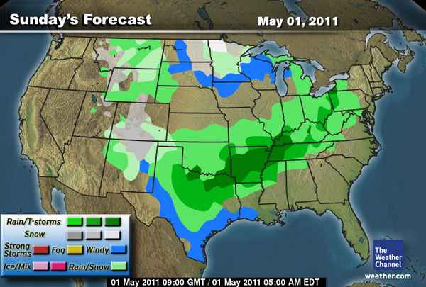
MORE STORMS LIKELY SUNDAY FROM E TEXAS TO KENTUCKY.
The boundary remains over the flood & storm zone and with tomorrow’s daytime heating kicking in by late morning and noon, onwards, the upper energy will once again spark showers, storms and some of those may become severe once again across east Texas, Arkansas, Missouri, up into Tennessee, Kentucky.

LOOKING INTO THE NEXT 2-4 DAYS
TEXAS LOOSES IT’S SUMMER-LIKE HEAT, RETURNS TO FALL FOR A FEW DAYS BEFORE REBOUND
Now, as we see a new storm system drop into the western trough from the Gulf of Alaska, a fresh cold surge will head south and this one will reach all the way to Texas, erasing the persistent 80s, 90s and 100s and bringing a huge 30 to 50-degree drop in temperature with some northern TX towns only getting into the 40s and 50s, on Monday and only 60s and 70s across the south. Way to the north, this very storm system will bring heavy snows from eastern Montana through the Dakotas and into Minnesota, even Wisconsin tomorrow (Sunday).

A REST COMING UP FOR MISSOURI, ARKANSAS, TENNESSEE, KENTUCKY FLOOD ZONE
After days of heat and humidity stretching from Texas to New York City, well, with the new system riding through the West and N. Plains, we will see the boundary over the flood zone shift east and in a few days, push through the East, bringing wet, possibly windy and much cooler air.
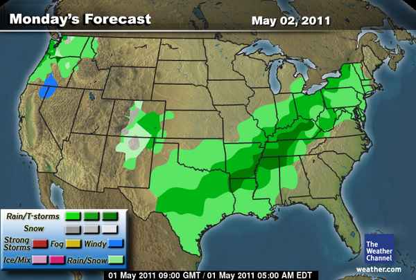
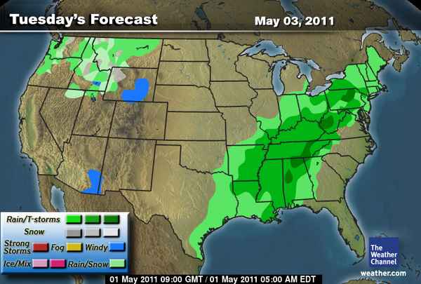
Precipitation Outlook across nation through Tuesday
Courtesy of The Weather Channel
WEATHER TALK
By Mark Vogan
European suggests UK will remain beneath high pressure, providing lots of sun, little rain!
Here are the latest European upper level pattern forecasts across Britain through next Saturday!!

Soils continue drying out, is a hosepipe ban looming?
WHAT’S REACHING TODAY’S BLOGS?
Severe Flooding To Continue, A Few Tornadoes, Too
Frank Strait, AccuWeather
WHAT’S ON TODAY’S WEATHERBELL BLOGS?
Using Misery to Drive home ones agenda… despicable
Joe Bastardi’s Blog, Weatherbell.com
April 30 Blizzard warning in North Dakota and the coldest April in 36 years in Pacific Northwest
Joe D’Aleo’s Blog, Weatherbell.com
THE EXTREMES OF THE DAY
TODAY’S US EXTREMES
COURTESY OF ACCUWEATHER
HIGH: 105 degrees at Laredo, TX
LOW: 0 degrees at Berthoud Pass, CO
TODAY’S UK EXTREMES
COURTESY OF THE MET OFFICE
HIGH: 72 degrees (22.3C) at Hurn (Dorset)
LOW: 29 degrees (-1.9C) at Braemar (Aberdeenshire)
TODAY’S EXTREMES HERE AT MY HOUSE
HIGH: 66 degrees
LOW: 47 degrees
Thanks for reading.
-Mark


Recent Comments