>FOLLOW THE BLOG ON FACEBOOK & TWITTER AND CLICK LIKE/FOLLOW FOR REGULAR LOCAL, NATIONAL AND INTERNATIONAL WEATHER UPDATES, LINKS & MORE!
TODAY’S TOP WEATHER STORIES
On Weather & Climate Through the Eyes of Mark Vogan

BREAKING NEWS
Reported tornado hits St. Louis airport
CNN
St. Louis Airport Closes Indefinitely After Tornado Rips Through Busiest Terminal
FOX NEWS
Tornado causes injuries at St. Louis airport
CBS NEWS
UK APRIL HEAT PEAKS WITH HIGHEST READING FOR THE MONTH SINCE 1949
The hottest Easter since 1949… but after 82F heat, storms and flash floods put a dampener on weekend
DAILY MAIL

TODAY’S WEATHER ACROSS UK & EUROPE By Mark Vogan
UK Heatwave of April, 2011 peaks at 82 degrees F or 27.8C at Wisley, Surrey… Major cooling trend to come…

Temperatures that had been roasting and focusing on Greater London during much of the week, spread north and up as far as Yorkshire & Lincolnshire where today it reached an amazing 25 to 26C breaking or coming close to record territory. The normal readings for this time of year of only around 12C (53F) was found 3,000-4,000 feet above the ground!
SCOTLAND RETURNED TO DISSAPOINTING RAIN, CLOUD AND CHILLY TEMPS WHILE MUCH OF ENGLAND SAW IT’S WARMEST APRIL DAY IN A LIFETIME
The warm air flowing around the high centered over northern France, the low countries of Belgium and Netherlands and the south of England may have increased, as an Atlantic cold front swung through Northern Ireland, Scotland and even into portions of Cumbria bringing us a sudden dose of April reality, dropping temperatures and pulling cloud and rainfall in from the Atlantic.
The presence of the northeast moving cold front may have increased the upper winds blowing up from the south around the high, thus forcing the warmer air that was concentrated over London and surrounding areas further north and up into the northeast of England.
This explains why areas such as Yorkshire and Lincolnshire saw highs go from 21 or 22C on Friday to 25 or even 26C today. The air across the south of England also got warmer than the previous day as pressures rose further, heating the 850mb level (5,000 feet above the ground) further, this supported even warmer afternoon temperatures around London despite the air cooling towards 10C even in central London and to 5 or 6C in the naturally cooler outlying suburbs away from the urban heat island by night.
It was clear to me, that with readings already well into the 20s C by 11am that if the sun remains strong and skies absent of clouds that it was going to be an even warmer day than Friday. This indeed turned out to be the case with many reporting sites throughout London reading 26 to 27C from 3pm onwards.
VERY WARM SURFACE CREATED THE INSTABILTY FOR THUNDERSTORM DEVELOPMENT, EAST WINDS WAS THE TRIGGER
A more prominant east wind blowing in off the North Sea, helped surface convergence and with hilly terrain, this aided in forcing the air upwards.
Many areas from Kent to Yorkshire & Northumberland saw pockets of cumulus clouds form, those clouds as the day wore on began expanding upwards as the increasing surface heat below excellerated the rate at which the air flowed vertically into the cooler upper reaches of the atmosphere where temperatures go be -40C or colder. A greater ‘lapse rate’ which is difference in temperature with height, means a greater environment for thunderstorms to develop and mature. Certainly with cold upper atmosphere and mid-20C heat, this was perfect.
These popup thunderstorms produced tremendous rains, gusty winds, hail and lots of dramatic lightning displays through this afternoon.
TODAY’S WEATHER ACROSS AMERICA By Mark Vogan
WEATHER CAUSING HAVOC ACROSS THE HEARTLAND
MAJOR FLOODING HIGHLY POSSIBLE OVER HILLY TERRAIN OF KENTUCKY & TENNESSEE
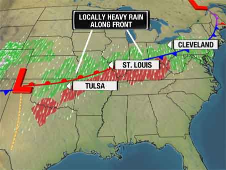
Moisture is pouring out of the Gulf and with a collision drapped across the heartland of the country in the form of a front, this moisture is being sucked into a towering wall of convective cumulonimbus towers that are energized by a strong northwest jet stream, chilly, dry air that’s being blown in on the storm’s rear and the warm, south, east surface wind. These two very different origins of air, the rotation of the low and varying directions of flowing air is creating the spin for strong but regular thunderstorms to transition to rotary supercells. The thunderstorms forcing piling air upwards where it literally forces more moisture and thus dumps heavier rains. This process will commence ‘training’ of these storms because of a slow movement of the cold front from Texas all the way to the Mid-Atlantic which will see a uniform 1-2 inch rains across northeast Oklahoma, much of southern Missouri, southern Illinois into the hilly terrain of Kentucky and Tennessee where there is flash flood concerns over this 2 to possibly 3 day event.

Details in Sunday’s post!
WEATHER TALK
By Mark Vogan
Heat over much of England and Wales this afternoon bubbles up the atmosphere, producing explosive thunderstorms!
WHAT’S ON TODAY’S WEATHERBELL BLOGS?
100 to 200 Hundred Tornadoes Sunday-Saturday … along with other items of “interest”
Joe Bastardi’s Blog, Weatherbell.com
Heavy rains, supercell tornadoes and cold in the news
Joe D’Aleo’s Blog, Weatherbell.com
THE EXTREMES OF THE DAY
TODAY’S US EXTREMES
COURTESY OF ACCUWEATHER
HIGH: 101 degrees at Laredo, TX
LOW: -4 degrees at Lake Yellowstone, WY
TODAY’S UK EXTREMES
COURTESY OF THE MET OFFICE
HIGH: 82 degrees (27.8C) at Wisley (Surrey)
LOW: 38 degrees (3.1C) at Aboyne (Aberdeenshire)
TODAY’S EXTREMES HERE AT MY HOUSE
HIGH: 53 degrees
LOW: 50 degrees
Thanks for reading.
-Mark


Recent Comments