>FOLLOW THE BLOG ON FACEBOOK & TWITTER AND CLICK LIKE/FOLLOW FOR REGULAR LOCAL, NATIONAL AND INTERNATIONAL WEATHER UPDATES, LINKS & MORE!
TODAY’S TOP WEATHER STORIES
On Weather & Climate Through the Eyes of Mark Vogan
Forecast a mixed bag for Texas firefighters
CNN
SIZZLING BRITAIN: IT’S LIKE SUMMER CAME EARLY THIS YEAR

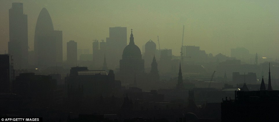
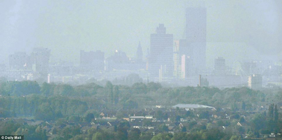
It’s like summer has arrived in full force an amazing 2 months earlier than when the first real warmth typically hits. What’s almost most interesting is, what tells us it’s not really summer yet is the nights are downright cold once the sun drops and it’s been dark for a few hours. Instead of those 15 to 18C lows which would be typical for the highs that are being experienced. London has been the hotspot with highs topping around 25 to 26C each day for the past 4 to 5. This stagnant air combined with summer level heat within the Greater London area is causing smog issues, yes smog… Last year during this months, we saw much of Britain shiver in both cold and snow, so the contrast couldn’t be greater.
Much of inland areas of England went beyond 21C with many spots hitting 22 to 25C
Up and down England, skies have been mostly clear and this has supported temperatures of 22 to 25C across a large area.
Fog, mist and cold winds kept temps up and down the east coast chilly
Interestingly, low cloud, fog, mist and a chilly onshore North Sea wind kept temperatures between 10-13C all day with a few spots actually remaining below 10C. This was in stark contrast to places perhaps only 10 to 15 miles inland where it was likely sunny, little wind was blowing and temperatures would have been registering 21 to 24C. Areas of Edinburgh struggled in single figures much of the day while readings as cool as 7C was registered at Leuchers, Fife while in striking contrast the Isle of Skye saw temperatures up to 22C. Prestwick, Ayrshire appears to have been one of the warmest places in Scotland today with temperatures reaching 23.1C.
The Scottish central belt saw dissapointing numbers with my own thermometer here in Lennoxtown, East Dumbartonshire reading only 19C. Glasgow I believe was close to this also for it’s daytime maximum. Some haziness and high level cloud likely filtered enough sunlight to restrict surface heating. Also, there was a keen east wind blowing all the way from the North Sea, channelled up the Firth of Forth and in between the Ochil Hills & Kilsyth and Campsie Fells to the north and Pentland Hills and Southern Uplands to the south. These chilly easterly winds blew straight into the Greater Glasgow area, supressing any real warming.
TODAY’S WEATHER ACROSS UK & EUROPE By Mark Vogan
Front now impacting western Scotland tonight with rain, London and much of England to see more low to mid-20s tomorrow
After what has been a dissapointing day temperaturewise across the Scottish central lowlands, it did warm past 21C in some sheltered Southern Upland locales, near or around 20C for southern, central and north Highlands areas. The warmest places today across Scotland appeared to be portions of Skye as well as Ayrshire where Prestwick topped 23.1C.
As for England, temperatures rose to 23, even 24C as far north as Cumbria. Yorkshire, the east and west Midlands saw 23 to 24C and this heat was also covering southwest, south-central and of course southeast England with the concentration of 24C or higher readings focused across the urban sprawl of Greater London. Heathrow airport to the west of central London reached 26.0C and this may have been the UK’s highest reading.
High Pressure remains strong through Saturday with similar temperatures forecasted across England, especially over southern, central and eastern areas. Far western areas may see more cloud and showers as a front is pressing in from the Irish Sea.
Scotland will have a very different day with mostly cloudy skies and periods of rain. Temperatures will only warm to the low teens, rather than high teens like we saw today. Eastern areas should see more sunshine and milder or warmer temperatures.
Highs across the southeast of England should top around 26, perhaps 27C tomorrow.
Paris, Brussels, Amsterdam across to Berlin and Warsaw will see plently of sun and highs reaching the low to mid-20s C. The high will shift slightly east, making way for the front to push into the western side of the UK.
Cloud, wind and rain should remain in control across the Iberian penninsula tomorrow and Sunday.
TODAY’S WEATHER ACROSS AMERICA By Mark Vogan
No respite for the Weather Weary US
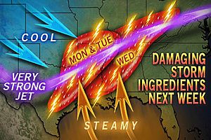
The rollercoaster, up and down, topsy turvy pattern that’s literally torturous and seemingly never ending spring pattern doesn’t look likely to end anytime soon. After highs rocketed during Wednesday across the Mid-Atlantic, it’s back to colder and more sunsettled weather. The East Coast is finding themselves with the leftovers of the ‘bigger weather’ the Mississippi-Ohio Valley has seen.
Unfortunately, these Pacific storms and their wicked fronts have been a great big fan and hair drier for the tinderbox that is Texas. La Nina’s classic spring setup has created a much bigger prblem than the US cmay have ever seen before both in the fires that continue to burn huge swaths of Texas and the wicked tornadoes that continue forming and creating havoc.
Next week looks set for more severe weather and tornadoes.
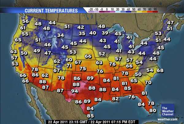
Philadelphia was 83 on Wednesday and today it’s struggled to get into the low 50s!
WEATHER TALK
By Mark Vogan
VAGARIES OF THE WEATHER
INDIA & SUB-CONTINENTAL ASIA WEATHER
BY RAJESH KAPADIA
The system in the South, an UAC, mentioned in Vagareis yesterday, is precipitating very heavy rains. Refer Vagaries Forecast Map put up yesterday.
Thunderstorms are reported from Kerala, T.N. and South interior Karnataka. Bangalore had rains today (Friday), measuring 44 mms in 9 hrs upto 5.30 pm, 68 mms in 2 days. Many centres in Kerala had heavy rains, figures of which will be known by tomorrow. Chennai is having frequent thundershowers on Friday.
As mentioned, the Nilgiris is currently receiving heavy rains, and figures have been received upto Friday. Some of the rainfall amounts in Nilgiri: Kodaikanal and Kotagiri 6cms, Combatore and Ketty 5cms.
In South Karnataka, many stations in Mysore and Hassan region got 4-6 cms of rainfall.
In Kerala, adjoining Wyanad region received 6 cms of rain. Rainfall figures for Friday will be out on Saturday, and amounts should be heavier.
As for the Vidharbha region, a direct report from “The Hitavada” a regional newspaper, speaks for itself. (Suggested by Akshay).
And the warming has commenced in the Sub-Continent.
Days have started warming up. Across the border, we see Nawabshah highest at 44c, and Karachi touches an unusual high of 41c on Friday. Now, as explained in the Vagaries Map, this heat should move east into Northern India from Sunday.
Click here to see our partner’s blog!
WHAT’S REACHING TODAY’S BLOGS?
Could Easter Feature 80 Degree Warmth?
Philly Weather
WHAT’S ON TODAY’S WEATHERBELL BLOGS?
Atlantic Cyclone.. a Tale of Two centers
Joe Bastardi’s Blog, Weatherbell.com
More stormy weather ahead
Joe D’Aleo, Weatherbell.com
THE EXTREMES OF THE DAY
TODAY’S US EXTREMES
COURTESY OF ACCUWEATHER
HIGH: 100 degrees at Laredo, TX
LOW: 1 degree at Stanley, ID
TODAY’S UK EXTREMES
COURTESY OF THE MET OFFICE
HIGH: 80 degrees (26.9C) at St James Park (Central London)
LOW: 31 degrees (-0.6C) at Braemar (Aberdeenshire)
TODAY’S EXTREMES HERE AT MY HOUSE
HIGH: 66 degrees
LOW: 37 degrees
Thanks for reading.
-Mark


Recent Comments