>FOLLOW THE BLOG ON FACEBOOK & TWITTER AND CLICK LIKE/FOLLOW FOR REGULAR LOCAL, NATIONAL AND INTERNATIONAL WEATHER UPDATES, LINKS & MORE!
TODAY’S TOP WEATHER STORIES
On Weather & Climate Through the Eyes of Mark Vogan
UK On track for warmest April on record, temps top 80 degrees in central London

The normal is 14C in London for late April, the normal for July/August is 22C
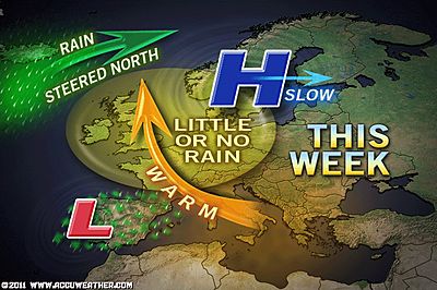
The UK sits beneath a high pressure cell that’s more fit for summer than April… Blame global warming or perhaps just blame a very dry late winter and spring which have dried up the soils which can dry out the air above the intensify high pressure overhead. Whatever way you slice it, we’re enjoying temperatures that’s HIGHER than even the warmest ‘average’ temperature is in midsummer.
Since Tuesday, everyday has topped 24C somewhere and that’s above the average for even midsummer. Quite amazing considering it’s only April and last year we saw high’s at time struggle to reach 3 or 4C in places with harsh frosts and even snow. Remember the Iceland volcano problems? That was last April and the whole problem came because of a strong northwest wind blowing over Britain which pulled all the ash down from Iceland. If that happened now, well all the ash would have went north towards Greenland and the North Pole and then likely dropped down into eastern Europe where they have been persistently cool, rainy with heavy mountain snows as far south as Turkey.
TODAY’S WEATHER ACROSS UK & EUROPE By Mark Vogan
Scotland to enjoy a very warm Friday, but complications move in from the west on Saturday!
While temperatures have been baking the south and central portions of Great Britain over the last 5 days now with little, if any rainfall for most, we finally see the pressures rise enough over Scotland which will surpress cloudcover and this stronger sunshine should pump temperatures across most inland areas of Scotland later this afternoon towards 22C with the odd one or two sheltered areas perhaps topping 24 or 25C. This will be after a pretty cool start where lows tonight may dip towards the 2 to 4C range under clear skies.
SCOTLAND’S FORECAST HIGHS BY MARK VOGAN
If you note the cooler temperatures along the eastern cities in my forecast below, this is due to both a thick har that will be prominant overnight as well as a blustery wind blowing in off the North Sea by day which will trim temperatures back. However, though fog and low cloud and mist may hang along the coast, keeping it pretty chilly even during the middle of the day with a high in some spots perhaps struggling to reach 11 or 12C, once inland, under sunshine and protected by hills, temperatures could well reach the low 20s C. For example, you may find Leven (Fife) struggle to see a high of 12 to 14C but 3-5 miles inland up in Kennoway, it may be closer to 20C. Glenrothes may see 21 or even 22C and it’s less than 10 miles from Leven, but the key is it’s inland, sunnier perhaps and sheltered from a cold sea breeze.
East
Aberdeen 17C (63F)
Dundee 16C (60F)
Perth 20C (68F)
Edinburgh 19C (66F)
The warmest spots in Scotland tomorrow are likely to be in interior places that are farthest inland, sheltered by large hills and where skies may be clearest. Stirling and Aviemore may be two places that could go either way, particularly Stirling with it perhaps exposed to a wind blowing up the Forth Valley. If there’s little wind and skies are sunny, we could see one of the warmest high’s in the central belt region in Stirling. Aviemore is often one of Scotland’s warmest places during warm spells. The Highlands (the towering Cairngorms sitting ‘east’ of the village acts like a giant windbreaker. Little wind, blazing sun and even a little trapping of heat in this valley can push Aveimore into the mid-20s C where everywhere else could be in the 18 to 20C range…
Central
Inverness 21C (70F)
Aviemore 23C (74F)
Stirling 24C (75F)
West
Glasgow 22C (72F)
Prestwick 21C (70F)
Stranraer 19C (66F)
Dumfries 23C (74F)
South of England to see high potential for ‘isolated’ PM thunderstorms
The south of England that has seen the core of the extremely warm April weather will see a greater chance of pop-up showers and isolated thunderstorms this afternoon as a more pronounced sea breeze manages to penetrate more inland areas today, this however shouldn’t stop another day where central London could push 26C once again like today and yesterday. As the land heats and that surface wind blows in, the heat building at the surface will create lift. Watch some of those puffy fair weather cumulus clouds bubble up from lunchtime onwards, you may see either showers and or storms build in the distance while it’s sunny everywhere else or one may build over you.
For the most part, it’s going to be another very warm, sunny day and showers and some storms will be highly localised so it shouldn’t spoil your evening BBQ’s.
Front to throw spanner in the works over Western Scotland late Friday and into Saturday
A front sitting off the west coast of Scotland is knocking on the door. This front will move close enough tomorrow night to perhaps push some showers, even some thunderstorms into the northwest Highlands, down through Lochaber and into the western Central Belt including the Greater Glasgow area. These showers may turn into thunderstorms (nothing major I don’t think) because there should be a decent amount of heat at the surface, adding a little upward excelleration of air, increasing the energy a little. However, if these showers build in later in the night, the air will have cooled and thus no thunderstorms, just some boring old showers.
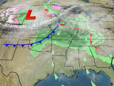
TODAY’S WEATHER ACROSS AMERICA By Mark Vogan
After a very warm Wednesday, heat gets slashed across Mid-Atlantic. Severe Weather targets Texas and Mississippi/Ohio Valley

WHAT’S REACHING TODAY’S BLOGS?
Satellite Shots: Big Thunderstorms in Texas, Mexico
Jesse Ferrell, AccuWeather
Tornado and Tropical Troubles!
Frank Strait, AccuWeather
THE EXTREMES OF THE DAY
TODAY’S US EXTREMES
COURTESY OF ACCUWEATHER
HIGH: 102 degrees at Laredo, TX
LOW: 7 degrees at Georgetown Lake, MT
TODAY’S UK EXTREMES
COURTESY OF THE MET OFFICE
HIGH: 79 degrees (26.3C) at Heathrow (London)
LOW: 31 degrees (-0.3C) at Ravensworth (N. Yorkshire)
TODAY’S EXTREMES HERE AT MY HOUSE
HIGH: 68 degrees
LOW: 46 degrees
Thanks for reading.
-Mark


Recent Comments