>Follow the Blog on Facebook & Twitter
TODAY’S TOP WEATHER STORIES
On Weather & Climate Through the Eyes of Mark Vogan
**HAVE WE ENTERED A PERIOD OF CLIMATIC HARDSHIP WHICH SEES THE INCREASE IN COLD OVER THE NORTHEAST AND THE STILL WARMER ATLANTIC WATERS OFFSHORE WHICH IS PRODUCING BIGGER SNOWSTORMS FOR THE BIG CITIES? SEE WEATHER TALK BELOW
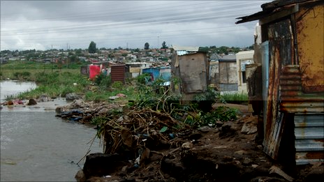
‘I don’t want to die’ in South Africa floods
BBC Weather
Japanese Volcano Erupts Ash, Rock
AccuWeather News
TODAY’S WEATHER ACROSS AMERICA
From AccuWeather
Denver to Detroit In For A Snowstorm Monday
By Katie Storbeck, Meteorologist
Snow Pesters the Northern Plains
By Katie Storbeck, Meteorologist
Severe Storms Threaten the South
By Meghan Evans, Meteorologist
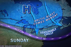
Fresh Arctic Air Headed to the Northeast
By Kristina Pydynowski, Senior Meteorologist
WEATHER TALK
By Mark Vogan
WHETHER THERE’S AN EL NINO (LIKE 09-10) OR A LA NINA (LIKE 10-11), THE BIG EASTERN CITIES GET SLAMMED BY MULTIPLE SNOWSTORMS BREAKING RECORDS
HAS THE NORTHEASTERN USA BECOME SNOWSTORM ALLEY???
It seems like those nearly snowless winters of 06-07 and 07-08 have become a distant memory as winter’s have not only become much snowier than normal but record-breaking snowy across the Northeast!
Why such big snowstorms from Philadelphia to Boston this year and from Richmond, Washington, Baltimore and Philadelphia last year? Well, the track of the low pressure train of course is the number one key as of course you need a storm to track across the Northeast tpo produce the largescale, heavy precipiation but in order for it to be snow rather than rain, the low pressure center must be to the south and east of the I-95 in order for the circulation to pull colder air in from the Ohio Valley and north rather than in off the warm Atlantic.
It appears that when low’s develop over the northeast Gulf or at least originate in the warm, sub-tropical waters and then move north, northeast around the base of the eastern N.A trough they draw warmer, sub-tropical properties north into a colder environment. Those winters of 06-07 and 07-08 were warm overall and thus any system trying to enter a relatively warm environment would clearly drop precipitation as rain or freezing rain. The cold in those winters were more centered over the Western US and Interior, not the East.
But last winter and this winter has appeared to see a large increase in both severity of cold that’s dropped south from the Arctic as well as coverage over the East and particularly Northeast region.
A POOL OF COLD AIR FURTHER SOUTH ACROSS THE US WITH LARGE-SCALE BLOCKING OVER CANADA MEANT THE STORM TRACK FOCUSED ON THE SOUTH AND SOUTHEASTERN USA IN 2009-10
Last winter saw a classic El Nino storm track and with a heck of a lot of cold air around over the central and southern US during the core of winter and warmth over Canada thanks to large-scale, powerful blocking high’s, the storms roamed the South and Southeast, the track was pushed further south (as expected with an El Nino), meaning the snowstorms (thanks to all the cold air getting far south) meant the snow corridor was focussed from Dallas to DC.
When lows form on the tail or base of the trough and this is positioned over the Gulf Coast region, their forced to ride up the East Coast when the trough axis is centered over the Ohio Valley. The nature of having a cold continent to the west and warm Ocean to the east, with the low cutting inbetween with it’s clockwise circulation, as the system gets to the latitude of the Virginia Capes/Hatteras the shape of the coast means that the low crosses a thermal boundary over the ocean surface which rapidly grows colder as the Gulf Stream which it followed from Florida to Jersey shoots off to the northeast and meets the southward flowing the Cold Labrador current meet, this as well the feel of colder air over the Ohio Valley and Ontario, Quebec means a rapid deepening of the low off New England. Superstorms such as this winter and last occur when you’ve still got a warm AMO (Atlantic Multidecadal Oscillation), especially in it’s later pahse which many believe it is, means warmer waters push closer to shore and thus waters nearer the Northeast are warmer and with lots of Arctic air overhead, this creates high octane fuel for blossoming Nor’easter’s to feed off of.
As the winters grow colder over the Northeast and waters remain warm offshore, this means we appear to be in a stormier, snowier pattern in this part of the world. Geography and current climatic period (perhaps a transition from warmer to colder times) mean we’re in a period of an increase in bigtime, major and crippling snowstorms. This area is of course home to some of the greatest snowstorms on earth and we have certainly seen a tremendous display of nature this year and last.
I do see more big storms during February and even March as colder air continues to feed down the heart of the continent.
VAGARIES OF THE WEATHER
INDIA & SUB-CONTINENTAL ASIA WEATHER
BY RAJESH KAPADIA
The current W.D. has precipitated scattered in all the regions of Pakistan. Though the rainfall did begin from Friday night, it was generally cloudy and light to medium rains were reported from there. Though Vagaries had anticipated rains in Sindh, Karachi far down in the South had good showers, as reported by Tyrone from there. 9 mms of rain was seen in Karachi today. Various places in Balochistan, Punjab (Pakistan) and the Northern regions had between 2 – 10 mms of rain/snow.
Now, as per the schedule, the system will move into India, and hopefully stick to the rainy schedule “prepared ” by Vagaries.-:)
And on the 31st, we see precipitation in Western and Central Nepal. Kathmandu will get more cloudy (low clouds) from tomorrow with upto 5 mms of rain on Monday. High will drop below 20c. Low will be around 3c and then drop from the 1st. to around 1c.
As mentioned earlier, expect a fresh W.D. from the 2nd.(Pakistan) moving into India.
In the South, the Easterly Wave is now active over Sri Lanka. The wave will have to make do with an embedded UAc, now E of Sri Lanka , for further enhancement of rains. Expect some “spill over” from this into South T.N. next 2 days.
For India, the Vagaries forecast map of yesterday should suffice as a valid forecast.
Night temperatures, already having risen marginally, will rise 2/3c in the North and Central regions next 2 nights. Days will be getting cloudy and cool.
Nights will again get cooler, albiet for 2 nights, by 2/3c in the region.
FOR GREAT INDIA, SUB-CONTINENT AND GLOBAL WEATHER, BE SURE TO CLICK HERE FOR OUR PARTNER’S BLOG!
MAJOR SANDSTORM SWOLLOWS DUBAI, UAE (SEEN FIRST ON VAGARIES!)
WHAT’S REACHING TODAY’S BLOGS?
Amazing High-Res Satellite of California Tule Fog
Jesse Ferrell, AccuWeather
Significant Storm by Wednesday
Brett Anderson, Canada Expert, AccuWeather
Thanks for reading.
-Mark


Recent Comments