>Follow the blog on Facebook & Twitter
TODAY’S TOP WEATHER STORIES
On Weather & Climate Through the Eyes of Mark Vogan
CORE OF COLD PUSHES OUT OF MIDWEST AND PRAIRES AND INTO EASTERN CANADA, AMERICAN NORTHEAST
THIS MORNING’S MIDWEST/PRAIRES, EAST LOWS
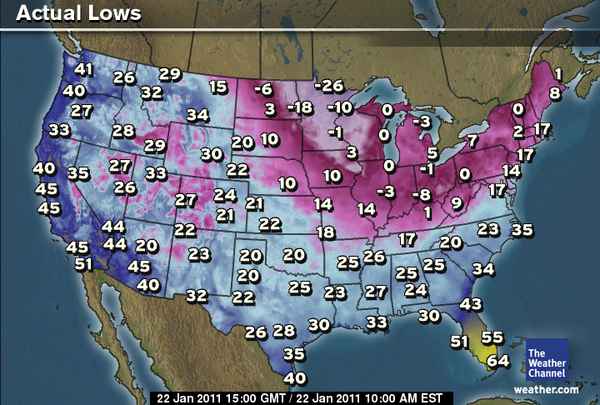
WINNIPEG, MB -35C, INTERNATIONAL FALLS, MINN -26F, DULUTH, MINN -10F, FARGO, ND -18F, MINNEAPOLIS, MINN -1F, CHICAGO, ILL 0F, PITTSBURGH, PA 0F, OTTAWA, ON -21C, MONTREAL, QC -18C,SPARTA, NJ -6F, NEW YORK, NY 14F, PHILADELPHIA, PA 14F
RIDGING, WHICH PRESENTS ALBERTA AND EVEN SASKATCHEWAN WITH ABOVE FREEZING TEMPS PUSHES CORE OF COLD TOWARDS QUEBEC, LABRADOR AND DOWN INTO THE AMERICAN NORTHEAST TONIGHT THROUGH MON, TUES!
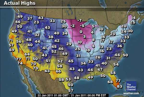
Today will certainly be a cold day throughout the Midwest, Lakes and up into the Canadian Praires after another brutally cold night with highs barely topping -5F in the American Northern Plains (north of the Twin Cities) and up into south-central Canada which saw Winnipeg tumble to -35C this morning. Minneapolis fell to -1F this morning, not too bad compared with yesterday morning and with a high of only around 5 or 6F, it will once again drop back below zero F tonight. Chicago after a low of zero this morning will warm into the 14 to 16F range this afternoon, another decent recovery from yesterday’s single-digit high.
MONTREAL WILL DROP BELOW -20C TONIGHT, NORTHEAST FACING COLDEST AIR SINCE 2005, PERHAPS EVEN 2004!
Montreal, Quebec fell to -18C this morning according to The Weather Network, Ottawa -21C and these numbers will be warmer than tomorrow’s highs! Tonight, I expect Ottawa, Montreal and Quebec City to fall between -21C and -25C under clear skies, light winds with strong Arctic high pressure overhead and tomorrow to barely recover at all. This will make way for what could be a remarkably cold night tomorrow night when Montreal may takle a run at -30C as well as Ottawa. Quebec City may push -35C, even further south into southern New England and towards the Atlantic coast which is home to nearly a quarter of the US population and the major cities of Washington, Baltimore, Philadelphia, New York, Hartford and Boston, temperatures will fall fast after high’s barely top 20 from DC to New York and 14 for Boston, winds whistling at perhaps as little as 2-5mph will make for a facenumbing day to be outdoors with near zero chills likely, Boston will likely drop towards 5 below by Monday Morning whilst NYC, Trenton, Philly and even Balt-DC will drop into single digits with everywhere feeling subzero with a stringing arctic breeze!
TODAY’S WEATHER ACROSS AMERICA
From AccuWeather
Northeast’s Coldest Weekend of Winter So Far
By Alex Sosnowski, Expert Senior Meteorologist
Next Weeks Snowstorm Is a Big Deal
By Alex Sosnowski, Expert Senior Meteorologist
South May Soon Welcome Beneficial Rain
By Kristina Pydynowski, Senior Meteorologist
California Weather Troubles This Weekend
By Kristina Pydynowski, Senior Meteorologist
WEATHER TALK
By Mark Vogan

CBS Boston predicting city to fall to -10 degrees!!!!
Whilst the core of exceptionally cold air remains over the Great Lakes and presses eastwards, the CBS Boston meteorologists are forecasting lows of 10 below zero in Boston with outlying areas perhaps falling towards 20 below! AMAZING and those numbers would beat the brutal cold of 2004 when Boston fell to 8 below, NYC 1 and Philly 3. As the front pushes through tomorrow, I am excited as to just how cold it will get across the New England area… Stay tuned!
TONIGHT TIES JANUARY 10 WITH JANUARY 11 FOR SUB-FREEZING NIGHTS AT MY HOUSE
After a relatively mild 37 high today and low which fell to 27 earlier last night and remained at a mild 31 through the overnight thanks to fog, rather than a cooler 18 degree low the previous night, tonight remains fogbound here and has done for some 2-3 days now (the reason my temp has failed to rise above 32 the past couple of days). So far, tonight’s temp has fallen to 28, no matter what, my thermometer has registered 17 nights at or below freezing and this ties the amount last January with this January. Any other night would mean January 11 beats last January for sub-32-degree nights!
WHAT’S REACHING TODAY’S BLOGS?
C-C-Cold and More Cold Coming
Jesse Ferrell, AccuWeather
The Cold, The Ridiculous Cold, and The Storm
Joe Lundburg, AccuWeather
THE EXTREMES OF THE DAY
TODAY’S US EXTREMES
COURTESY OF ACCUWEATHER
HIGH: 81 degrees at Indio, CA
LOW: -35 degrees at Waskish, MN
TODAY’S UK EXTREMES
COURTESY OF THE MET OFFICE
HIGH: 49 degrees (9.6C) Tiree (Western Isles)
COLD HIGH: 33 degrees (0.7C) at Glasgow (Strathclyde)
LOW: 19 degrees (-7.3C) at Shap (Cumbria)
TODAY’S EXTREMES HERE AT MY HOUSE
HIGH: 37 degrees
LOW: 27 degrees
TODAY’S CONDITION’S (LOCALLY)
After bottoming out at 27 degrees late last evening when fog lifted enough to allow some surface warmth back to space, fog then quickly re-established itself densely and thus drew temps back to around 30-31 degrees through the overnight, a much milder night than the previous night when skies remained clear and allowed temps to fall into the upper 10s. However with the heavy, moist air and the air below freezing, this allowed a glace ice to form on the ground and on outdoor objects. The car was covered in this icy glace which was tough to scrape off, it also made walking on pavement s and driving slippery. The day overall wasn’t too cold but with dense fog lingering all day and the large moisture content harnessed in the air, made it “feel” cooler.
Thanks for reading.
-Mark


Recent Comments