>TODAY’S TOP WEATHER STORIES
On Weather & Climate Through the Eyes of Mark Vogan
Described As: An Inland Tsunami!
New Areas of Queensland, Australia Devastated By Severe and Extreme Flash Flooding.
SEE THE LATEST VIDEOS ON THE FLOODS VIA YOUTUBE.COM BELOW…
Australia floods: Brisbane braces for surge
BBC
Disaster declared as Australia flood death toll rises to 10
CNN
TODAY’S WEATHER ACROSS SCOTLAND & UK
HEAVY SNOW OVER THE SOUTHERN HIGHLANDS, INCLUDING THE A9 IN PERTHSHIRE AS WELL AS OVER SOUTH LANARKSHIRE AT THE BLACKWOOD TO BEATTOCK SUMMIT STRETCH THIS MORNING MAY BE REPEATED MORE WIDELY THIS EVENING AS ATLANTIC PRECIPITATION ROLLS INTO AN INCREASINGLY COOLING AIRMASS TONIGHT
By Mark Vogan
My back garden temperature as of 6pm this evening is down to 27 degrees (-2.7C) under clear skies. Indeed temperatures didn’t get out of the 30s today as a clearer, calmer pocket of air has been pulled in from the NW behind yesterday and early this morning’s rain and snow. Even by 2.30pm you could feel the air growing cooler and ice never really left the ground today. By 3pm cars were already beginning to show the early signs of frost formation…
After what was a very snowy night over Stirlingshire, Perthshire on northwards and indeed just south of Blackwood, near Lesmahagow where I was trucking southbound, only to find snow on top of a sheet of ice on the M74’s high stretch between Happendon and Abington services with easing of the treacherous conditions once down by Beattock summit. Yes, from estimating the depth of the snow at the sides of the motorway and indeed in the service areas, there was a good 2-5 inches lying in the higher ground of South Lanarkshire. A pretty impressive fall of snow. Therefore last night when heavy, persistent rain was continuing to erase our snowpack here, heavy snows were falling from Lesmahagow southwards and not too far to the north over the tops of the Campsies just a few miles from my front foor and in perfect view from my office here looking north.
Tonight, the concern is that as the air grows colder with temperatures perhaps falling down towards -4 or even -6C (21-24 degrees), nasty icing already on the roads will worsen before another band of precipitation moves in from the Atlantic with heavy rainfall along the coast, readily turning to snow as it moves inland. It’s said by forecasters that “significant accummulations” is possible over higher ground. That would be the west, northwest and southern Highlands (Argyll, Lochaber, where there was major snow and ice problems focused in this area this morning) as well as perhaps the highest routes over Ayrshire, South Lanarkshire, Dumfries and Galloway eastwards towards the Lothains and Borders where as much as 4-6 inches may fall. Now, even low levels may, for a time, see accummulating snow as the crucial lowest mile of the atmosphere continues cooling, also helped by the fact that it remained cool throughout the day. 1-3 inches overnight isn’t outwith the realms of possibility before a transition to rain which may create a nightmare morning rush hour tomorrow, particularly through the central region network which is busiest in the country and has already been severely hit this winter.
DESPITE A 24-HOUR DELAY TO REAL MILD WEATHER, THURSDAY LOOKS PROMISING…
However, in saying all this, after today’s 30s, tomorrow will warm towards 41-42 degrees (5-6C) through much of the Central Belt, perhaps 36-41 degrees for the Highlands (2-4C) and come Thursday, we’re looking at highs touching 50 degrees (10C)in Glasgow across towards Edinburgh… FINALLY!
TODAY’S WEATHER ACROSS AMERICA
From AccuWeather
BREAKING NEWS: NORTHEAST PREPARES FOR SNOWSTORM TONIGHT!
Intensifying Storm to Slam NYC, Boston
By Andy Mussoline, Meteorologist
Flight Delays and Cancellations Spreading Across US
By Heather Buchman, Meteorologist
Snow Spells Travel Trouble For Chicago, Indianapolis, Detroit
By Katie Storbeck, Meteorologist
Coastal Snow, Then Potential Flooding
By Alex Sosnowski, Expert Senior Meteorologist

WEATHER TALK
By Mark Vogan
US WEATHER: A COLD START COAST TO COAST
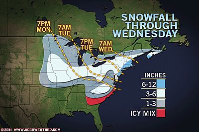
TODAY’S SNOWFALL: MIDWEST 2-4″ (LOCALLY 6″), OHIO VALLEY AND INTERIOR MID-ATLANTIC 4-8″ (HIGHER TOTALS IN MTNS), I-95 CORRIDOR 1-3″ IN SOUTHERN END INCL BALT-WASH, PHILADELPHIA TO BOSTON 5-12″ BUT 12-18″ UNDERNEATH BANDS

COLD START, PARTICULARLY OUT WEST!
As you can see from the above graphic, it was a frigid start to Tuesday throughout the Great Basin and Rockies with many areas well below zero and the coldest basins and valleys of Wyoming, Colorado, Utah and up into Montana likely saw lows dip to between 15 and 25 below zero under the perfect combo of clear skies, light winds and deep snowpack. The high elevation, dry cold air also aids in the extremely cold temperatures at this time of year Out West.
A system is currently pushing southeastwards through the Ohio Valley and this is currently bringing snowfall from Minneapolis to Chicago, Detroit, Indianapolis and Pittsburgh where likely 2-4 inches will fall with locally higher amounts. Behind this, cooler air will roll in. As for the Northeast where the much anticipated “blizzard” is expected tonight and tomorrow. The southern I-95 including the Baltimore-Washington area should see no better than 1-3 inches but as the Midwest system joins forced with a system riding north off the Carolinas, the entity will simply become the larger, more dominant coastal low and this will bomb-out off the Mid-Atlantic coast, between the relatively warm Atlantic and it’s moisture and the colder, drier air pulling in from the Midwest, this storm will ramp up pretty good through the overnight. I believe within those narrow bands 15 to 20 inches of snow is possible and accompanied by thundersnow and snow rates of 2-4 inches per hour. Where those “narrow, intense bands” line up is hard to tell, but it’s possible they could cross the heart of the urban I-95 and present NYC or Boston with higher than expected amounts….
We shall wait and see… I’m off to bed, back up at 1.40am tomorrow!
CHECKOUT THE BRAND NEW MEXICO-BASED
WILD WEATHER ON A WILD WORLD Blog
BY ARTURO SALINAS
WHAT’S REACHING TODAY’S BLOGS?
Video Update on the Big Daddy Storm Coming.
Henry Margusity, AccuWeather
Northeast Blizzard to be Followed by More Cold
Joe Lundburg, AccuWeather
THE EXTREMES OF THE DAY
TODAY’S US EXTREMES
COURTESY OF ACCUWEATHER
HIGH: 84 degrees at Tamiami, FL
LOW: -29 degrees at Gunnison, CO
TODAY’S UK EXTREMES
COURTESY OF THE MET OFFICE
HIGH: 49 degrees (9.6C) Isles of Scilly
COLD HIGH: 29 degrees (-1.8C) at Loch Glascarnoch (Highland)
LOW: 16 degrees (-8.9C) at Altnaharra (Sutherland)
TODAY’S EXTREMES HERE AT MY HOUSE
HIGH: 37 degrees
Low: 32 degrees
TODAY’S CONDITIONS
A very wet overnight which saw heavy rain and sleet here at lower levels and heavy snow above 600 feet (tops of the Campsie Fells, a few miles to the north) as well as higher routes including the M74 to the south and up over the other side of the Campsies with treacherous snow and ice conditions in Stirlingshire, Perthshire etc. Here skies cleared near sunrise allowing the temperature to hit freezing and icing to form, making for very slippy conditions, those conditions remained throughout. Much of the day saw good spells of winter-sunshine, cooler than yesterday with highs only at 37 degrees here. Tonight will cool into the upper 20s before cloud, sleet and snow rolls in.
Thanks for reading.
-Mark


")


Recent Comments