>I would like to wish all my readers
A Very Merry Christmas
to all of you….
-Mark
Your January Forecast
By Mark Vogan
AFTER A SEVERE PERIOD OF COLD AND SNOW, JANUARY WILL BE MILDER, BUT DOESN’T RULE OUT THE CHANCE OF SNOW NOW AND AGAIN!
We all know how nasty the period from November 25th through December 25th has been and I’m sure you’ll be reading this thinking, I hope he has something positive for us, since we’re heading into what is typically is the “coldest period” of the year.
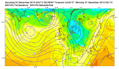
Well, the good news is, milder air from the Atlantic will return to British airspace and sooner than you think.
In fact after what will likely be more snow for areas of Scotland, Northern Ireland and other areas of the UK today and particularly tomorrow (Boxing Day) which will be moisture moving in off the Atlantic and not North Sea will allow Atlantic air to help rise temperatures over a very frozen Britain. The moisture that will bring the Christmas Day and Boxing Day snowfall will be from the Atlantic as said and this means the snow won’t last as this type of air flow will help bring 5-8C highs and nights asbove freezing, bringing an end to the snow and ice. With ground temperatures well below freezing, the thaw of snow and particularly ice will be a slow process but will be very evident over the next 36 to 48 hours for most of us and it appears as though that warmth will hang around through New Year and likely throughout much of January. In saying that, there will be a very large, powerful Arctic influence over much of Europe and we will be mighty close to it here in the UK, therefore, though I believe the month OVERALL will be much much warmer than what we’ve indeed seen. The Cold Arctic air that’s been so dominant is in the process of migrating east into central and eastern Europe and therefore we can enjoy rainier, windier and generally mild days and nights. Gales may indeed return with the classic Atlantic-dominating pattern finally returning. From Berlin to Moscow and throughout eastern Europe including Turkey, Romania, Ukraine, Bulgaria, what we have endured, we’ll ity’s your turn now. However, in saying all this, periodically over the upcoming month, that cold pool may be too cold to not bring “brief snow and cooler weather” back and thus I wouldn’t be surprised to see the return of snow and cold.
Don’t worry though, that snow and cold will be shorter lived and less intense. In fact the snow may be more like what we have seen during the warmer winter’s back in the 90s and early to mid-2000s. Where it may snow in the morning, it may be gone by dinner time as Atlantic air will try and get in on the backside of the cooler air.
Winter weather: December ‘set to be coldest since 1910’
BBC Weather
The Extremes of the Day
Today’s US Extremes
Courtesy of AccuWeather
High: 77 degrees at Key West, FL
Low: -13 degrees at Big Piney, WY
Today’s UK Extremes
Courtesy of the Met Office
High: 44 degrees (6.5C) at Tiree (Western Isles)
Cold High: 14 degrees (-9.9C) at Castlederg, Co Tyrone
Low: -1 degree (-18.2C) at Altnaharra (Sutherland)
The Extremes of the Day
High: 31 degrees
Low: 11 degrees
LAST CHRISTMAS
Snowcover: 2-4 inches on the ground
CONDITIONS: Partly cloudy skies after a low of 24 degrees and a high of 31 degrees.
TODAY’S CONDITION’S
Snowcover: 1.2 inches
A fresh overnight covering of snow brought a sharper, beautiful Christmas-perfect scene here locally as well as in Aberdeen, Edinburgh and Glasgow. The overnight started off cold with lows dipping to 11 degrees but slowly moderated as snow bearing clouds rolled in during the overnight hours bringing those snowshowers. At around 9am, the temperature has risen to 21 degrees and the snow has came and went, meaning it was likely snowing with air temperatures in the upper 10s to around 20, cold for snowfall here!. Interestingly, it was raining around 10am despite a temperature of 28 degrees, this shows that milder air of Atlantic origin was overhead, in spots that rain would have been “freezing rain” with a freeze on contact with the very cold ground. The day overall was fairly mild (mildest in over a week) with mostly cloudy skies which gave way to clearer skies by evening, this allowed temps to cool off into the mid 20s and will continue to fall, likely into the 10s. The high once again failed to reach freezing.
Hope you have a wonderful Christmas 2010.
-Mark


Recent Comments