>Today’s Top Weather Stories
On Weather & Climate Through the Eyes of Mark Vogan
As forecasted, the worst of today’s snow, wind and blizzard conditions have struck and remained north of the Population-core of Scotland. After a “showery morning with flurries, it was all about the drop in temp and today’s wind chill leaving many “weather hypers” out in the cold!
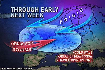
ICE WARNING FOR ALL OF GREAT BRITAIN AS ARCTIC AIR CONTINUES TO DRAIN SOUTH OVER THE NEXT 24 TO 48 HOURS
This afternoon’s BBC Scotland Forecast by Judith Ralston
How’s Scotland looking tonight?
Central Belt: Mostly clear skies, cold northerly breeze, windchill ranging from -6 to -12C, icing conditions will worsen!
After a night which saw temperatures climb from around freezing at 5pm last night to all the way up to 6C (44 degrees) during the early hours of this morning, this was thanks to the presense of the Arctic air mass as it began to push into the far north and as it did so, the jet stream dropped down over our heads, turned winds out of the west, southwest and thus pulled in warm Atlantic air. However for those few hours of milder air, then came the arrival of Arctic air as temps plunged within 20 minutes by as much as 3C and 6C over the course of just 2 hours at Edinburgh. Indeed my own thermomemter dropped from 6C at 5.15am to 1C at 7.15am. With rain showers off and on turning readily to snow showers, this rapid freeze meant wet surfaces were inevitably going to ice over and certainly this afternoon as temps continue falling, icing and slippery conditions are going to become the primary hazard tonight on roads and pavements.
Temperatures should range from -4 to -8C with possibly colder in areas which see little wind, clear skies and perhaps even have snow remaining on the ground. As of 4pm this evening, my thermometer is now reading -3C (26F) and continues to fall fast. There is no wind and skies are clear. If it remains calm and clear, I believe a -10C low by morning is possible since truely frigid Arctic air is now established over Scotland.
The North: Heavy & Persistent snow showers will continue along with strong to gale-force northerly winds making the -2 to -4C air feel closer to -13C or colder, blowing and drifting may be severe in exposed and remote areas
As for snow, if you head up to Perthshire on northwards into the Grampians and Cairngorms, Caithness, Sutherland and up over the Northern Isles, you’ll find stronger northerlies and frequent snow showers, some heavy and persistent, allowing further accummulation to what we’ve already seen up there today. Temperatures in the -2 to -4C range and winds blowing at 20 to 30 mph uniformly, windchill values may drop towards -20C in areas across particularly exposed, higher routes as well along the Moray, Aberdeenshire, Caithness coast that’s exposed to those gales. Blowing and drifting will also be a major hazard for driving. In saying that, there will be areas across the Highlands, particularly those more sheltered Glens which hardly see clouds, never mind heavy, winddriven snow. Some areas may hardly feel that numbing wind chill slide through the 4-6 layers of clothing many of you up there will NEED and therefore sections of the Highlands may find colder air temperatures, perhaps below -10C this evening.
BBC Snow Update by Nick Miller
Today’s Weather across America
From AccuWeather
By Alex Sosnowski, Expert Senior Meteorologist
By Heather Buchman, Meteorologist
By Kristina Pydynowski, Senior Meteorologist
Holiday Travel Next Week: How are the Roads and Airports Looking?
By Henry Margusity, Expert Senior Meteorologist
Weather Talk
By Mark Vogan
What’s Reaching Today’s Blogs?
Jim Andrews, International Expert, AccuWeather
Jesse Ferrell, AccuWeather
Joe Lundburg, AccuWeather
Ken Clark, Western Expert, AccuWeather
The Extremes of the Day
Today’s US Extremes
Courtesy of AccuWeather
High: 86 degrees at McAllen, TX
Low: -28 degrees at Babbitt, MN
Today’s UK Extremes
Courtesy of the Met Office
High: 49 degrees (9.5C) at Isles of Scilly
Cold High: 28 degrees (-2.3C) at Lerwick (Shetland)
Low: 24 degrees (-4.4C) at Lerwick (Shetland)
Today’s Extremes here at my house
High: 44 degrees
Low: 18 degrees
Snowcover: Patchy
By Mark Vogan


>Congratulations with your short term forecast. On the east coast, there was insignificant sleet/rain working its way south overnight. A dusting of snow for the east coast followed (1 mm or so). A cold wind followed bringing temps down to freezing level. We have had snowcover on the ground since the end of November. That remains the case. Snowcover on a local scale varied hugely: snow depth was generally 1 foot to 4 feet deep. I thought the stories of 4 feet of snow were porkies but they were in fact true. Temps dropped to – 21 degrees C in west lothian. Widespread temps were at one point between -6 and – 13 degrees C (approaching mid-day).