>Today’s Top Weather Stories
On Weather & Climate Through the Eyes of Mark Vogan
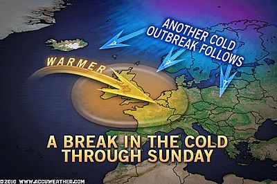
Whilst Great Britain warms as Atlantic air replaces Arctic, the USA’s eastern third now has it’s turn with old man winter
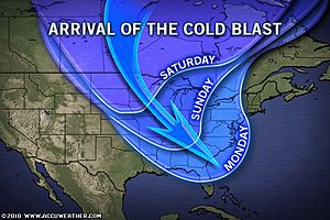
Subzero Cold Seizing Minneapolis to NYC Next Week
AccuWeather News
New Cold Wave, Snow Aim for U.K., Europe
AccuWeather News
EXERPT FROM ACCUWEATHER ARTICLE PUBLISHED TODAY.. IN FULL ABOVE!
According to AccuWeather.com Meteorologist and Climate Expert Joe Bastardi, the first week of December was the coldest opening week of December in central England since 1879. What is more, it is the second coldest opening week here since the earliest records were taken in 1659, he said.
Minus nine degrees in mid rush hour spells danger today
Scotsman
Today’s Weather across AmericaFrom AccuWeather
DUE TO TIME RESTRAINTS, I AM UNABLE TO SUPPLY THIS SEGMENT TODAY, SORRY
Weather Talk
By Mark Vogan
From Wednesday’s morning’s 3 to Thursday’s 40!
A remarkable swing in temperature as Atlantic air is back in business but a hangover from the Arctic visit will linger as pipes burst, motorways remain dangerous icerinks and high heating bills drop through the letter box
It’s been an impressive display from old-man winter over the past 10 days to 2 weeks as it appears we’ve endured here in the UK the harshest period, so early since perhaps 1910. It has indeed produced the biggest UK November snows since 1965 and the biggest snow to Edinburgh since 1963, a location in which in areas, has seen as much as 30 inches of snow.
Even when looking at temperatures over the past few days alone for my own site that is located in my back garden, the numbers are quite amazing for a location in Scotland which don’t forget is typically a temperature and highly oceanic influenced, therefore extremes don’t “typically” happen. Not unless we’re starting a little ice age all over again, are we? Perhaps it’s just coincidence, eh?
OK, take Monday’s 33-degree high, indeed this was the day much of central Scotland was crippled by 2 to as much as 12 inches of snow, that night saw the start of a deep push of brutal Arctic air which wrapped in right on the heels of those infamous snowclouds that will likely be remembered by many motorists for the rest of their lives,. As high pressure rolled in, this cleared skies out completely and dropped temps to 16 degrees by Tuesday morning, that day only mustered a mere 21-degree high, coldest so far, in fact up until then, the coldest high, wasn’t all that cold (30 degrees), well I guess it was cold until Tuesday anyway. Then after that 21-degree high was topped, the truely cold stuff then came in that night as temps dropped below last winter’s lowest readings, firstly last December’s minimum of 13 degrees was surpassed before midnight, then the January low of 12 degrees, which was until this week, the lowest reading ever recorded here at my house. By morning when I had awaked, the temp was 9 degrees! Lower than id ever imagine id record here, especially with last winter’s persistent cold readings which I thought couldn’t be matched, never mind broken. After falling to 9, then bouncing back to 10, just prior to and even just slightly after sunrise, the temp dropped back and below 9, stopping at an impressive 8.4 degrees. Even at 11.30am, it remained very cold with 14 degrees still. The high for that day topped 21. By 4.30pm, it had fallen to 11 degrees and by 6pm, 9 degrees! Even by 9pm, the temperature had matched the previous morning’s low…. All night it hovered around 7 degrees with fog trying to get up here from the south, it always got so far, even circled all around, but always disipated and pulled back. This allowed the “perfect conditions” to remain of crystal clear skies, no wind, a solid 8 inch snowcover and Arctic air firmly in place. By daybreak, the temperature read a frozen 3 degrees. Remarkably cold for a typically “mild climate”!. Interestingly after that 3-degree low and 10.30am reading of just 7 degrees, the high managed to creep all the way to 20 degrees!! Ouch, this beat the previous day’s high of 21 degrees and actually makes this a close 2nd for coldest high recorded at my site, (coldest being 19 degrees). The low crept back down to 13 degrees and then rose and levelled off at a chilly, yet warmer 14 degrees, it’s amazing at when temps are above 10-degrees, it’s “warmer”, the slow climb then began last night as milder air started to cross overhead at the midlevels. The frigid air hanging on top of the snowcover, meant Atlantic air wasn’t getting down to the ground, no chance… Clouds also drifted overhead throughout the night, showing not only the arrival of a different air mass, but help keep temps up during the night. Amazingly, the 18-degrees I woke up to and stepped out to this morning did actually feel warm, compared to 3 degrees. A few days ago, 18 degrees would have felt bitter and also would have been the coldest low of the season….!
Indeed, as today wore on and clouds flooded in, the snowmelting process began kicking in and pipes burst, the Atlantic air pushed the Arctic air east and thus we warmed well to a somewhat balmy 40 degrees for the high. An impressive recovering from not only last night’s 13 degree low, the vast contrast between high’s (20 degrees verses 40 degrees) but just looking at the fact that it was 3 yesterday morning and this evening my same thermometer is reading 40 degrees and you can hear both dripping as well as the splash of cars driving through water filled streets as the snow begins shrinking….
For this who hate this cold weather, I’m sorry it appears to be returning NEXT WEEK… shaping up nicely with the forecast I put out on October, 31st.


The Extremes of the Day
Today’s US Extremes
Courtesy of AccuWeather
High: 81 degrees at El Centro, CA
Low: -10 degrees at Embarrass, MN
Today’s UK Extremes
Courtesy of the Met Office
High: 48 degrees (9C) at Macrihanish (Kintyre)
Cold High: 35 degrees (1.5C) at Lerwick (Shetland)
Low: 7 degress (-13.8C) at Topcliffe (Yorkshire)
Today’s Extremes here at my house
High: 40 degrees
Low: 13 degrees
TODAY’S CONDITIONS
Snowcover: 7.5 inches
AFTER A COLD LATE DAY YESTERDAY WITH A FALL TO 13 DEGREES LAST NIGHT FOR AN OFFICAL LOW, OVERNIGHT READINGS CLIMBED EVER SO SLOWLY AND BY DAWN THEY WERE UP TO 18-DEGREES BETWEEN 5.30-8AM, STILL COLD FOR SURE, BUT NOTHING LIKE WHAT WAS SEEN AT THE SAME TIME YESTERDAY MORNING. AS TODAY WORSE ON UNDER MOSTLY CLOUDY SKIES, TEMPS WARMED TO 39 DEGREES FOR THE HIGH, DOWNRIGHT BALMY COMPARED TO YESTERDAY’S 20 DEGREE HIGH, A RISE OF 19 DEGREES AND AN AMAZING 37-DEGREE RISE FROM YESTERDAY MORNING’S ALL-TIME LOW OF 3 DEGREES… ALL THIS THANKS TO THE RETURN OF WARMER AIR OFF THE ATLANTIC!!
Thanks for reading.
-Mark


")


")
Recent Comments