>Follow this blog on Facebook & Twitter and Become a Fan today!
Today’s Top Weather Stories
On Weather & Climate Through the Eyes of Mark Vogan
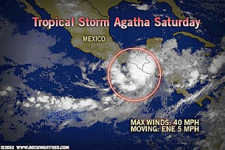
Tropical Storm Agatha Near Central America in Eastern Pacific
AccuWeather News
Pacaya Volcano, Tropical Storm Agatha Target Guatemala
AccuWeather News
Today’s Weather across America
From AccuWeather
Thunderstorms Drench Parts of the Eastern US
AccuWeather
Blazing Heat to Bake West Next Week
AccuWeather
Relief from Heat Coming to Northern, Central Plains
AccuWeather
Weather Talk
By Mark Vogan
Big time heat builds over central and Eastern USA
Fargo, North Dakota yesterday warmed to an impressive 95 degrees, it also touched the 90-degree mark in the Twin Cities and upper 80 across the Chicagoland area. Houston, Texas warmed to 96 degrees and really the heat was strong from Houston to Fargo with many areas warming into the mid to upper 90s! A more zonal flow is now holding the cold air to the north and allowing the heat build northward anywhere east of the Rockies. The stubborn western trough is going to leave next week allowing the first true heat build over the Southwest where Phoenix may top 100 and Death Valley may take a run at 110 degrees which would be warmest of 2010 for the lower 48.
UK remains cool and unsettled but slight warming trend for upcoming week
It appears the unsettled pattern may continue, however despite a continued threat to showery weather through this week, temperatures will warm slightly and it looks like the south of Britain (away from the coast) should warm into the mid to upper 70s by Wed-Thurs and even Scotland should see highs top out at around 70 or slightly higher by Wed-Thurs… Those forecasted numbers may rise so check back here for more info..
Canary Islands and Sahara warming up more and the African Wave train will react to this warming!
I’m noticing the highs which have generally been around 68-72 degrees across the Canary Islands, which are situated off the northwest Africa coast and are a classic tourist destination for Brits and other European countries and now heating up thanks to intensifying High pressure at this latitude as we approach the month of June. Several key things worth noting here.
Highs are going to start regularly topping the mid to upper 80s (this week) over the Canaries where skies remain cloud-free, the beauty is, these islands though at the same latitude as the Sahara, remains relatively cool thanks to the cold Canary current, which makes these surrounding waters cooler than you’d think and the heating of the islands themselves and the cool waters, generate a well developed sea-breeze which makes these islands as good of a place to go as the Caribbean if not better as these islands have cool water surrounding and not, bathtube warm waters which make for a very humid heat and lesser releaf from a sea breeze. In my opinion, the lesser humidity thanks to colder surrounding waters would make the Canaries much more comfortable than those tropical island in the Caribbean Sea. If you like 88-90 degree heat and mid to upper 70 degree humidity and refreshing thunderstorms in the late afternoon as well as a hurricane threat, you’d prefer the Caribbean, if you like 88-92 degree heat, no cloud and low humidity, you’ll enjoy the Canaries.
If you pay attention, North Africa is starting to really heat up and you’ll begin to see the Sahara Desert warming into the 40-50C (102-122F) range from now until late August and this intense heating of the Sahara is going to produce an east flow where the Inter-Tropical-Convergence-Zone or ITCZ is located… The African Wave Train will begin to roll producing intense thunderstorms which will rise what is know as the African Easterly Jet or AEJ and this will be what brings “waves” off from across the equatorial region of Africa from Ethiopia all the way across and off the Senegal coast and out across the Tropical Atlantic. When the heat builds across the Sahara, this air rushes south where it will be forced to rise nearer the equator where the air is much more moisture laden and bouyant and this will produce thunderstorms, a type of equatorial thermostat, keeping balance with the intense heating over the Sahara Desert. These waves or thunderstorm clusters are the seedlings to what can eventually grow and develop over the 80 degree plus waters of the Tropical Atlantic Ocean and become future tropical storms and eventually hurricanes..
What’s Reaching Today’s Blogs?
Oil Spills & Hurricanes Don’t Mix
Paul Douglas Weather Blog (Weather Nation)
Today’s US Extremes
Courtesy of AccuWeather
High: 100 degrees at Pecos, TX
Low: 13 degrees at Bodie State Park, CA
Today’s Extremes here at my house
High: 59 degrees (heavy showers)
Low: 48 degrees
Thanks for reading.
-Mark


Recent Comments