>Today’s Top Weather Stories
On Weather & Climate Through the Eyes of Mark Vogan
Check your Airline for the latest info (scroll through list for your Airline WHICH IS IN “YESTERDAYS” POST)
Breaking News Flights to resume as of 2200 Tuesday but some no-fly zones exist
Breaking News: Many UK Airports Re-closed again today due to fresh ash cloud progressing southeast from Iceland
OBSERVATIONAL NOTES FROM MARK VOGAN
(8.30am BST)We live in the flight path of Glasgow Airport and with clear skies and a beautiful morning, I haven’t heard nor seen any plane this morning as of 8.30am Tuesday.. The skies are absent of even residual or old vapor trails from any aircraft. (Mark Vogan)
(TUES PM)Some flights did indeed go from Glasgow this morning but they were few and far between compared to “normal” however GLASGOW AIRPORT IS NOW ONCE AGAIN CLOSED AMID FEARS OF A NEW ASH CLOUD CROSSING BRITAIN..
INTERESTING AND IMPORTANT!
Snapshot of North American and European flights
BBC Here
The eruption of the Icelandic volcano Eyjafjallajokull has brought disruption to the skies over Europe.
The maps above (very bottom of article below) show how flights have been restricted to flying around the ash cloud, shown in red. Where the shading is darkest, it indicates the cloud is extending higher into the atmosphere.
The flight ban was was partially lifted on Tuesday – five days after the eruption. EU transport ministers agreed to allow limited flights within Europe after flight tests showed the density of the volcanic ash in the air was diminishing.
Meteorologists have been using computer models to predict which direction the ash cloud will travel.
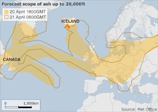
The map above, provided by the Met Office shows how the ash cloud is forecast to alter its position in the next 24 hours.
Latest weather reports from the BBC Weather Centre suggest the wind direction is changing and this should blow the ash cloud away from the UK and other parts of Western Europe, by the weekend, clearing the skies for normal flights to resume.
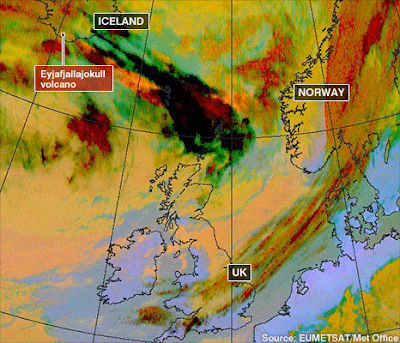
The satellite maps above show how the ash cloud spread over the first couple of days after the eruption. The black and dark red colours indicate the passage of the ash cloud, where the density of particles in the atmosphere is greatest. More satellite images of the eruption and cloud can be seen here .
Scientists now believe the worst of the ash cloud has passed – but geologists say the volcano could resume erupting at any time. The end of an eruption is officially declared only three months after the last seismic activity.
here is the effect this “moving” ash cloud is having on flights (below)
19 April
20 April
21 April
Breaking News Statement which will allow flights to resume for UK
Chaos persists as Europe flights resume
BBC Here
Eyjafjallajokull Ash Cloud “Worsening” Situation
AccuWeather Here
Bigger Iceland volcano lurks
Weather Channel/Associated Press Here
Today’s Weather across America
Storm Continues Lashing West with Rain, Wind and Snow
AccuWeather Here
Severe Weather Outbreak Looms for South
AccuWeather Here
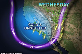
Today’s Graphic courtesy of AccuWeather.com
Weather Talk
By Mark Vogan
LATE SEASON COLD NIGHT FOR SCOTLAND, FLURRIES SPOTTED TODAY AT LOW LEVELS
Despite my house thermometer reported a though chilly, a still moderate 50-degree high, the actual feel was much cooler with generally mid-40s for much of the day and a wind which likely made it feel closer to the upper 30s. More likely in early April but hey, we’re still in April so anything can happen.
A cold northwest wind allowed precipitation to border on the “wintry side” believe it or not and those sleet flakes were reported here at my house this afternoon for a very brief time as well as in other parts of the country… We have high pressure in control. The same one which produced a 61 degree high just a few days ago but now that the “core” of the high has shifted and those clockwise winds have alkso shifted more from the north and west, colder air is being allowed to push across Britain slicing as much as 10 degrees off highs over the last few days… Tonight under clear skies and colder air in place above our heads, that chilly air will decent to the surface during the short hours of darkness.. (The short hours of darkness we see this time of year) saves us from seeing major chilly temps by morning/ However we may be heading for 20s, yes 20s tonight and that doesn’t happen all that often at this late point in April…
Don’t worry, flurries mixed with rain and highs only managing 8-10C and nights that drop to -1 to -2C can’t last and when the wind blows for the right direction (southwest or south) our temps with the help of that strong sun, will boost readings back into the 60s and soon enough, the 70s….
Is it possible this “cold night of April 20-21, 2010” be colder thanks in part to “clearer, cleaner” air through lack of aircraft over Scotland and Britain? who knows eh..
My forecast high tonight here at my house in a low of 29 degrees…
What’s Reaching today’s blogs?
Cold Storm Continues To Impress
Ken Clark, AccuWeather Here
Severe Thunderstorms, Tornadoes, Lightning All Down in 2010
Jesse Ferrell, AccuWeather Here
For information updates not seen on this blog, check out the Facebook Fan Page and have your say by writing on the “Wall”, also feel free to post a photo by clicking here!
Thanks for reading.
-Mark


Recent Comments