>
 Graphics courtesy of The Weather Channel
(This post will be updated with the latest on cold and snow totals)
To be honest with you, Easterners haven’t had too bad a time from old man winter this January but it looks as though the cold is ready to catch up and will produce a bone-chilling close to January 2010.
US-CANADA starting to get colder while Europe and Asia is Frigid
The US finally appears to be looking and feeling the air that’s driving severe cold and snow into much of Europe and Asia, the extent to this cold is remarkably large and intense with -20C air in central Europe with even -25 to -30C from Poland to the Ukraine and -30 to -45C across the heart of interior Asia from Kazakhstan to northern China, -50C cold is showing up in the heart of Siberia, remember this Asian continent is 3 TIMES LARGER than that of North America and therefore it gets even colder than northern Canada’s frozen wasteland.
The very tapping into Siberia vast reservoir of frozen air via a cross-polar flow will drive very cold air into the US in the coming days and weeks and as pressures build into the northern tier states and across the Eastern third, the air grows colder and colder as the Arctic high expands over most of the country “east of the Rockies”. The stratoshere is warming and this is evident in the nature of how the cold is despersing across the hemisphere. Remember most of Europe and Asia is beneath a blanket of cold, Arctic air now and here in the British Isles, we shall see colder and colder times as the westward advancement of this enormous cold pool pushes into us as we eneter February. I wouldn’t be suprised if Feb 2010 opens it’s first 10-day period as one of the coldest of all-time.
Eastern Snowstorm
Southern Plains to Mid-Atlantic
It will be from a storm system now crossing the Four Corners that will, once east of the Rockies will create havoc across the Plains over the next 24 to 36 hour period and eventually over the Appalachains and into the coastal plain of the Mid-Atlantic region which includes the Washington DC to Baltimore to Philadelphia urban corridor and may extend further north into the Greater NYC area and even Boston.
SPLIT FLOW
There are two different upper-level air flows within the US atmosphere, one from a NW direction which is transporting Arctic air into it’s trough which is down over the Northern Rockies, Northern Plains, Upper Midwest and into the Great Lakes and northern New England. The other flow is out of the W-SW and pushing milder, moister air in off the Pacific. The Arctic air is only dropping so far (central plains and up to northern New England and a push of mild air is unabstructed west to east from the Southwest all the way to New York. The colder air however is slowly migrating south and east as the Arctic high, aided by a trough deepening stratospheric warming and cross polar flow event as well as the progressive large-scale hemispheric pattern.
The area of low pressure will ride the “southern jet stream” east from Arizona through Texas on eastbound through Mississippi, Louisiana, Alabama on out towards South Carolina and the Atlantic Ocean.
As for the “northern jet stream” that’s over the Northern plains states will push southbound TOWARDS the warm, more energetic southern branch which of course is where the low is riding the tracks. Arctic high pressure sits above the Northern branch and southward moving Arctic air and a low getting pumped with milder, moisture laden air pushing in from the Pacific is ready to create havoc on the southern Plains as a major snowstorm which will be found across Oklahoma, Arkansas into the high country of the Carolinas and Virginias where anywhere from 1-2 inches to as much as 6-12 inches could be expected from this system. There may be locally 16 inch amounts as I wonder whether more moisture being pulling up from the Gulf by this system and the pulling southbound of the very cold air from Canada could produce greater snow amounts, particularly through orographic lift in the Appalachains and other upslope areas.
The High over the Midwest and New England will likely stop this low from turning up the East Coast and blasting New England with heavy snowfall, however DC to Baltimore and perhaps even up to Philadelphia may end up seeing a decent snowstorm out of this depending on where it’s track goes and whether it can nudge far enough north. I do see DC and Baltimore with at least 4 inches, Philadelphia 4″ and New York perhaps 1-2 inches, Boston may be spared with this.
The possibility however also lies with a further north progression of moisture up into the I-95 from DC and Boston and with all the cold air in place, we may see 4-8 in DC (locally a foot in places) up through Baltimore and Philly and 6 inches as far north of NYC and 4″ even up in Boston..
FRIDAY MIDDAY STORM UPDATE:
The heart of central Texas is seeing the core of this major storm system currently with heavy, windblown north NORTH OF I-20 in north Texas with Oklahoma City seeing 20s with strong NE winds yesterday and heavy snow whilst just the previous day, highs topped out at a balmy 65 degrees… South of the system heavy rain, thunderstorms and wind damage have been reported.
A Major icing event between heavy snow event to the north and thunderstorm event to the south
The ice storm track while likely occur from San Angelo through Dallas, south of Tulsa through Little Rock and into Memphis. Much of Tennessee may be in on the ice event which could be a major deal with a half to as much as an ice of icing which will bring down tree limbs and power lines etc.
FRIDAY EVENING UPDATE ON THE ARCTIC AIR
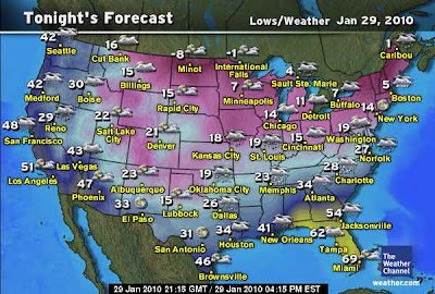
Tonight will be the coldest night of winter so far for the I-95 corridor where low teens is expected from Washington DC through Baltimore, Philadelphia on up to New York City and single digits will impact the Boston area. After lows below zero this morning across much of the Midwest with the coldest low in the nation up at Embarrass, Minnesota of -25, -15 in Duluth and -4 in Minneapolis whilst Chicago falls to 5 degrees. Despite the typically harsh wind chills, this air really isn’t unusual or even particularly cold to be honest as for a morning on the 29th of January, it could be MUCH colder. As for the cities of the East Coast, a low of 14 degrees like the weather channel are forecasting, again, isn’t bad for this time of year. If it were the -18 in Chicago like last January or the -22 like in Minneapolis last January, or the 1-degree in NYC back in January 2004, then you’d be saying it’s COLD. So far I am unimpressed by the cold so far but I am optimistic that February could bring a decent Arctic wave that will raise my weary US cold-searching eyebrows. The cold really has been grabbing my attention more on this side of the pond where Europe and Asia are suffering from brutal cold with the core of the worst cold centering itself these days over Germany…
Meanwhile, what is impressing me right now is the major winter storm which is all but going to paralyze a region from the TN through Virginia corridor where upwards of 24 inches of snow may fall… Mjaor icing is also grabbing attention too so I shall post more on storm totals tomorrow… As for the now, I am off to bed as I am back up at 2am for my drive down to Dumfries once again in the morning.
Thanks for reading.
-Mark
Email Superior37@hotmail.com


")


Recent Comments