> This from The Weather Channel talks about NASA photo above
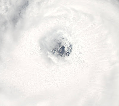
Here is just a stunning, beautiful picture taken on Tuesday around lunch time by NASA’s MODIS Aqua satellite. As the sun rises on the Eastern Seaboard, uncertainly remains as people waken to a violent Atlantic hurricane looming 1,700 miles from The Outer Banks.
 The beautiful view over top of Hurricane Bill.
 Perfectly symmetrical, deep convective tops that have a temperature of -80C rim the eye of Category 4 Hurricane Bill.
Hurricane Bill continues to intensify over the warm waters of the western Atlantic, now a fully fledged and very powerful category 4 storm with maximum sustained winds now clocking 135 mph. A recent pass through the eyewall by a 4am flight by the Hurricane Hunters recorded a 147-mph gust. Well formed features such as the Central Dense Overcast, beautiful symmetrical shape and perfect outflow illustrates a healthy storm. Eyewall cloud tops are said to be -80C, compared to probably 30C within the eye at the top of the storm. A contrast that’s needed to sustain and fuel such a powerhouse system. As I predicted, this storm has become fully formed, powerful and luckily not close to any landmass at this time. I expect a continuation of strengthening for the next 24 hours before possible “peaking”. I would not be surprised if Bill neared or topped category 5 status but may level off at sustained winds of 145-150 mph. Remembering atmospheric and oceanic heat content must be perfect to support a system so powerful, a lot of heat energy and transfer must be processed to fuel such a machine. The stronger a storm is or gets, the harder it is to support it. Increased inflow at the surface and recycling of heat exchange from ocean heat to kenetic energy which feeds the systems inner circulation must be exchanged at a more rapid and excellerated rate. In order for us to run faster, our heart and inner organs must work harder to support that increase in running speed. Same goes of this hurricane and all hurricanes.
As for Ana, not much.. looking like it’s dissapearing altogether, however, as it treks into the eastern Gulf we will need to watch that area for possible “lighting up”..
I shall talk more on Bill’s dynamics and surrounding environment later as well as what’s ahead!
Later I shall also talk more about the heatwave thats baked the Northeast, Ontario and Quebec.
Have a great day.
-Mark
 This from The Weather Channel talks about NASA photo above
 As the sun rises on the Eastern Seaboard, uncertainly remains as people waken to a violent Atlantic hurricane looming 1,700 miles from The Outer Banks.
 The beautiful view over top of Hurricane Bill.
 Perfectly symmetrical, deep convective tops that have a temperature of -80C rim the eye of Category 4 Hurricane Bill.


Recent Comments