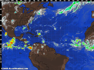
Despite the poorer look to both depression two and the larger secobdary wave behind it, though the convection is not as intense there is still good lowe level circulation associated. A lot of the problems TD. 2 is encountering right now is strong upper shear that tearing appart the thunderstorms that are trying to fire up around the center and also dry air which is wrapping into it’s center also and trying to chock this system, however, it remains a good circulation and is still doing a good job at pull with it, all the dry Saharan dust away from the large ciculation behind it. There are several key components to this situation to remember.
1) The tropical Atlantic is not as warm as previous few years. i.e since the major seasons of 04 and 05, there has been a marked cooldown of these waters between Cape Verde and the Leeward Islands, so that has a limiting factor.
2) The amount of Saharan dust this year spread across the Atlantic is choking convection.
3) Stronger than normal easterlies are creating a flow too fast for many storms to allow vertical building and with upper-level westerlies also blowing hard… these are 3 major factors that are denting potential tropical development this season.
In say ALL this, the waves in the eastern Atlantic will create a threat, at least one if not both, also a wave moving towards the Leeward Islands will likely create showers and thunderstorms into Fla and Gulf this weekend. That system is going to encounter the islands of Cuba, Haiti and possibly Jamaica will may forbid this particular wave for developing.
Why do I think the eastern twins are likely to devlop. TD 2 may or may not devlop but as stated, it’s the secondary tailback that’s got the green light as it’s moving into a prepared, moistened up environment thanks to frontrunner, as these system push west, they will eventually experience warmer waters, rather than marginally warm enough waters, shear is likely to weaken into next week as well as a less dusty air. It’s the shear size of system two may play a major role in keeping it alive throughout the crossing of the Atlantic.
What’s very interesting is that we have seen, will see flare ups and downs of these tropical waves throughout the next days and weeks, one minute, we will look from face value, shouting, OH THAT THING’S GOING TO BE NAMED ANY MINUTE…. Then bang, where did it go? I key here it look closer and looking at it’s state, what’s it’s clouds doing, what’s the circulation’s health like? It may appear to dissapear, but doesn’t mean it’s not there, plus all you need in a window of oppertunity and boom, you get a blow up and brings intensification to a storm that looked very inocuous but was there all along…
The current graphic above shows a flare up and healthy looking wave north of Haiti and Dominican Republic, we will need to closely watch that as we enter the weekend and it progresses towards to straits and sneeks into the warm, deep waters of the Gulf, it may join forces with a front that’s going to swing out into the Gulf off the US coast and that may cause a problem. But just look at that thing now off south of the Cape Verde island, I would not be surprised if that thing absorbs TD 2.
Thanks for reading.
-Mark
 http://hurricane.accuweather.com/hurricane/atlantic/basin.asp
 http://hurricane.accuweather.com/hurricane/atlantic/basin.asp
Recent Comments